IMAGES TAKEN NEAR TO
Edmondsley, DURHAM, DH7 6EG
Introduction
This page details the photographs taken nearby to DH7 6EG by members of the Geograph project.
The Geograph project started in 2005 with the aim of publishing, organising and preserving representative images for every square kilometre of Great Britain, Ireland and the Isle of Man.

There are currently over 7.5m images from over14,400 individuals and you can help contribute to the project by visiting https://www.geograph.org.uk
Image Map
Images are licensed for reuse under creativecommons.org/licenses/by-sa/2.0
Notes
- Clicking on the map will re-center to the selected point.
- The higher the marker number, the further away the image location is from the centre of the postcode.
Image Listing (11 Images Found)
Images are licensed for reuse under creativecommons.org/licenses/by-sa/2.0
Image
Details
Distance
1
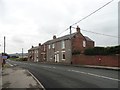
Terraced miners houses at Blackhouse
This little hamlet of miners cottages was built just before the First World War at a crossroads south of Craghead. There was already a pub here, which gave its name to the village. The houses here are Dyson's Buildings on the right, and Thompson's Buildings on the left.
Image: © Robert Graham
Taken: 9 Sep 2019
0.01 miles
2
Approach to Blackhouse
Coming into the little hamlet of Blackhouse from the south along Black House Lane. This is a little hamlet of former miners' cottages south of Craghead. Built just before the First World War.
Image: © Robert Graham
Taken: 9 Sep 2019
0.02 miles
4
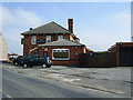
The Black House Inn
This country pub is now a private house called Charlaw View. The former pub gave its name to the little mining hamlet here, which dates from the early 20th century. The pub is older and was probably built at the crossroads here in the early 19th century. The present building is not that old of course, and appears to have been rebuilt in the late 19th century.
Image: © Robert Graham
Taken: 9 Sep 2019
0.04 miles
5
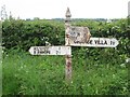
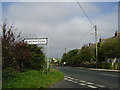
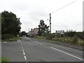
Old Direction Sign - Signpost by the B6532, Beech Grove Terrace, Edmondsley Parish
Spiked ball finial - 3 arms; by the B6532, in parish of Edmondsley (Chester Le Street District), Beech Grove Terrace, Edmondsley, junction with Wheatley Green Lane.
Surveyed
Milestone Society National ID: DU_NZ2249
Image: © M Rayner
Taken: 30 May 2016
0.04 miles
6
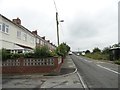
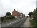
Front view of Beechgrove Terrace
In the little hamlet of Blackhouse, near Craghead. Built just before World War I, probably for miners in the local pits. The former pub, the Black House Inn, can be seen at the far end. This predates the hamlet, but is now a private house.
Image: © Robert Graham
Taken: 9 Sep 2019
0.05 miles
7
Looking across to Blackhouse
View of Beechgrove Terrace from Lowery Lane, on the road to Craghead.
Image: © Robert Graham
Taken: 9 Sep 2019
0.06 miles
8
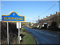
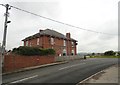
Beechgrove Terrace, Blackhouse
Blackhouse appears to consist of very little more than Beechgrove Terrace. The blue and yellow road sign is characteristic of a style of signage introduced by County Durham some years ago - compare the image http://www.geograph.org.uk/photo/245749 of a few years earlier.
Image: © Trevor Littlewood
Taken: 30 Jan 2013
0.10 miles
9
Charlaw Inn near West Edmondsley Co Durham
Image: © P Glenwright
Taken: 23 Sep 2006
0.11 miles
10
Humbledown Lane at Blackhouse
Looking north at the road junction with Lowery Lane, on the left. These houses form part of the hamlet of Blackhouse near Craghead.
Image: © Robert Graham
Taken: 9 Sep 2019
0.15 miles