IMAGES TAKEN NEAR TO
Melbourne Villas, DURHAM, DH7 6BG
Introduction
This page details the photographs taken nearby to Melbourne Villas, DH7 6BG by members of the Geograph project.
The Geograph project started in 2005 with the aim of publishing, organising and preserving representative images for every square kilometre of Great Britain, Ireland and the Isle of Man.

There are currently over 7.5m images from over14,400 individuals and you can help contribute to the project by visiting https://www.geograph.org.uk
Image Map
Images are licensed for reuse under creativecommons.org/licenses/by-sa/2.0
Notes
- Clicking on the map will re-center to the selected point.
- The higher the marker number, the further away the image location is from the centre of the postcode.
Image Listing (7 Images Found)
Images are licensed for reuse under creativecommons.org/licenses/by-sa/2.0
Image
Details
Distance
2
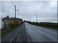
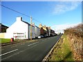
B6532 entering Daisy Hill
Daisy Hill lies between Edmondsley and Sacriston; the road is entering from the south.
The road sign in blue and yellow is in colours widely used in County Durham for such notices.
Image: © Trevor Littlewood
Taken: 1 Oct 2018
0.03 miles
4
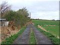
Track towards Nettlesworth West House Farm (footpath)
Image: © JThomas
Taken: 31 Mar 2012
0.19 miles
5
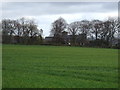
Farmland towards Nettlesworth West House Farm
Image: © JThomas
Taken: 31 Mar 2012
0.22 miles
6
Daisy Hill
This is a small hamlet on Edmondsley Lane, between the villages of Edmondsley and Sacriston. These are all former mining villages.
Image: © Robert Graham
Taken: 28 Nov 2012
0.23 miles
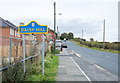
7
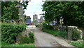
Nettlesworth West Farm House
Entrance to farm
Image: © Malcolm Coils
Taken: 23 Jun 2017
0.23 miles