IMAGES TAKEN NEAR TO
Peartree Terrace, DURHAM, DH7 0DY
Introduction
This page details the photographs taken nearby to Peartree Terrace, DH7 0DY by members of the Geograph project.
The Geograph project started in 2005 with the aim of publishing, organising and preserving representative images for every square kilometre of Great Britain, Ireland and the Isle of Man.

There are currently over 7.5m images from over14,400 individuals and you can help contribute to the project by visiting https://www.geograph.org.uk
Image Map
Images are licensed for reuse under creativecommons.org/licenses/by-sa/2.0
Notes
- Clicking on the map will re-center to the selected point.
- The higher the marker number, the further away the image location is from the centre of the postcode.
Image Listing (6 Images Found)
Images are licensed for reuse under creativecommons.org/licenses/by-sa/2.0
Image
Details
Distance
1
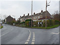
Peartree Terrace
Small hamlet on the road between Burnhope and Holmside.
Image: © Oliver Dixon
Taken: 31 Oct 2014
0.01 miles
2
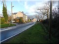
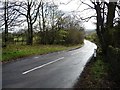
Peartree Terrace from the west
Looking down Holmside Lane to this little hamlet east of Burnhope.
Image: © Robert Graham
Taken: 28 Nov 2012
0.02 miles
3
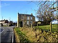
Peartree Terrace
Tiny hamlet on Holmside lane a couple of kms east of Burnhope.
Image: © Robert Graham
Taken: 28 Nov 2012
0.03 miles
4

Field east of Peartree Terrace
The field lying on the north side of a minor road not far from the village of Burnhope has the residues of the snow and ice that had lain during the previous two weeks.
Image: © Trevor Littlewood
Taken: 30 Jan 2013
0.12 miles
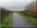
6
Holmside Lane near Whiteside Farm
Heading east to Holmside.
Image: © Christine Johnstone
Taken: 14 Apr 2012
0.24 miles