IMAGES TAKEN NEAR TO
Tursdale Business Park, DURHAM, DH6 5PG
Introduction
This page details the photographs taken nearby to Tursdale Business Park, DH6 5PG by members of the Geograph project.
The Geograph project started in 2005 with the aim of publishing, organising and preserving representative images for every square kilometre of Great Britain, Ireland and the Isle of Man.

There are currently over 7.5m images from over14,400 individuals and you can help contribute to the project by visiting https://www.geograph.org.uk
Image Map
Images are licensed for reuse under creativecommons.org/licenses/by-sa/2.0
Notes
- Clicking on the map will re-center to the selected point.
- The higher the marker number, the further away the image location is from the centre of the postcode.
Image Listing (7 Images Found)
Images are licensed for reuse under creativecommons.org/licenses/by-sa/2.0
Image
Details
Distance
1
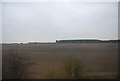
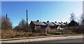
Industrial building by the railway line at Tursdale
Image: © N Chadwick
Taken: 21 Feb 2011
0.05 miles
5
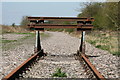
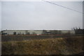
The End of the Line
A buffer stop marks the end of the short spur of track on what was the Leamside route between Tursdale Junction and Pelaw Junction. This was the first route of the main line from York - Newcastle, before the section between Tursdale Junction and Relly Mill junction at Durham was built in 1872. The bulk of the line closed in 1991, track was lifted in 2013.
Image: © David Robinson
Taken: 15 Apr 2014
0.15 miles
6
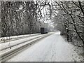
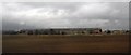
Wintry Tursdale
An HGC negotiated the A688 at Tursdale after heavy snowfall.
Image: © David Robinson
Taken: 8 Jan 2021
0.15 miles