IMAGES TAKEN NEAR TO
Bowburn, DURHAM, DH6 5NQ
Introduction
This page details the photographs taken nearby to DH6 5NQ by members of the Geograph project.
The Geograph project started in 2005 with the aim of publishing, organising and preserving representative images for every square kilometre of Great Britain, Ireland and the Isle of Man.

There are currently over 7.5m images from over14,400 individuals and you can help contribute to the project by visiting https://www.geograph.org.uk
Image Map
Images are licensed for reuse under creativecommons.org/licenses/by-sa/2.0
Notes
- Clicking on the map will re-center to the selected point.
- The higher the marker number, the further away the image location is from the centre of the postcode.
Image Listing (11 Images Found)
Images are licensed for reuse under creativecommons.org/licenses/by-sa/2.0
Image
Details
Distance
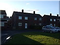
1
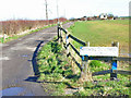
Whitwell South Farm, Bowburn
The rather faded sign makes reference to the "Whitwell School of Motoring" - another example of agricultural diversification?
Image: © Oliver Dixon
Taken: 10 Apr 2006
0.05 miles
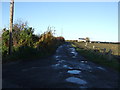
6
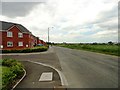
View along Tail Upon End Road
This wonderfully named lane runs along the northern edge of Bowburn village, south of Durham. Although flanked by a modern housing estate, it is of much older origin and is shown on the first O D map from the 1860's.
Image: © Robert Graham
Taken: 19 Jun 2013
0.17 miles
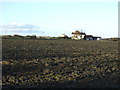
8
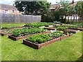
Vegetable Garden
Vegetables in raised beds
Image: © David Robinson
Taken: 26 Jun 2014
0.19 miles
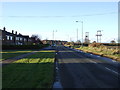
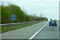
9
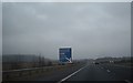
A1(M) sign
A mile north of Junction 61 for A688 (Bp Auckland)/A177 (Peterlee).
Image: © Stanley Howe
Taken: 10 Apr 2013
0.21 miles
10
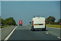
Shincliffe : A1(M)
Heading north on the A1(M).
Image: © Lewis Clarke
Taken: 21 Sep 2020
0.22 miles