IMAGES TAKEN NEAR TO
Croxdale, DURHAM, DH6 5JN
Introduction
This page details the photographs taken nearby to DH6 5JN by members of the Geograph project.
The Geograph project started in 2005 with the aim of publishing, organising and preserving representative images for every square kilometre of Great Britain, Ireland and the Isle of Man.

There are currently over 7.5m images from over14,400 individuals and you can help contribute to the project by visiting https://www.geograph.org.uk
Image Map
Images are licensed for reuse under creativecommons.org/licenses/by-sa/2.0
Notes
- Clicking on the map will re-center to the selected point.
- The higher the marker number, the further away the image location is from the centre of the postcode.
Image Listing (8 Images Found)
Images are licensed for reuse under creativecommons.org/licenses/by-sa/2.0
Image
Details
Distance
2

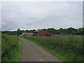
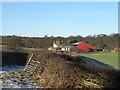
Low Butterby Farm, near Durham
Located at the end of a long farm road, on the inside of a large meander of the River Wear. Low Butterby operates as a distribution centre for organic farm produce.
Image: © Oliver Dixon
Taken: 26 Dec 2005
0.06 miles
3
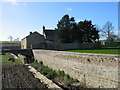
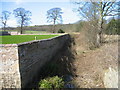
Low Butterby moat
The Gatehouse Web Site: Strong House. Moated and walled. The Elizabethan gatehouse, mentioned as the main survival by King, was demolished in 1966, despite being a Scheduled Ancient Monument. The moat is dry and measures c.8m wide and averages c.3m deep. The inner wall is of stone and brick, 3m high with a plinth course running along the major part of its length. Butterby, formerly Beautrove, is first noticed when Roger d'Audre was granted a licence to have a chapel or chantry within his oratory, which he had built within his manor of Beautrove. In c.1240, the manor passed to the Lumleys, and it was probably the occasional residence of this family until 1566 when it passed to the Chaytors.
Image: © Les Hull
Taken: 12 Mar 2008
0.07 miles
8
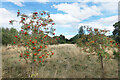
Rowan Trees, Low Burnhall
Low Burnhall is a fairly recently established bit of forest managed by the Woodland Trust.
Image: © Des Blenkinsopp
Taken: 24 Aug 2022
0.20 miles