IMAGES TAKEN NEAR TO
Newburn Avenue, DURHAM, DH6 5AJ
Introduction
This page details the photographs taken nearby to Newburn Avenue, DH6 5AJ by members of the Geograph project.
The Geograph project started in 2005 with the aim of publishing, organising and preserving representative images for every square kilometre of Great Britain, Ireland and the Isle of Man.

There are currently over 7.5m images from over14,400 individuals and you can help contribute to the project by visiting https://www.geograph.org.uk
Image Map (Loading...)


Getting Data...Please wait
Leaflet Map data © OpenStreetMap
Images are licensed for reuse under creativecommons.org/licenses/by-sa/2.0
Notes
- Clicking on the map will re-center to the selected point.
- The higher the marker number, the further away the image location is from the centre of the postcode.
Image Listing (11 Images Found)
Images are licensed for reuse under creativecommons.org/licenses/by-sa/2.0
Image
Details
Distance
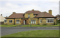
2
Site of Bowburn Colliery
The last remaining part of the site of Bowburn Colliery (1906 - 1967) not to be incorporated into the industrial estate. The fencing surrounds the site of the downdraft shaft which was the coal extraction shaft.
Image: © David Robinson
Taken: 12 Sep 2018
0.14 miles
3
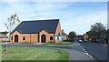
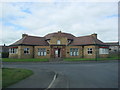
Parish Church of Christ the King
This modern Anglican Church in Bowburn is at the crossing of Prince Charles Avenue and Bede Terrace.
Image: © Trevor Littlewood
Taken: 9 Oct 2018
0.15 miles
4
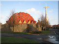
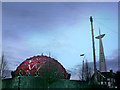
Church of Christ the King, Bowburn
Built in 1976, this striking futuristic church stood in the former mining village of Bowburn. Unfortunately, it suffered serious design faults and was closed in September 2004. At the time of photography the building was in a sorry state with the roof in a poor state of repair, and the whole premises fortified like Fort Knox against vandals. The building was demolished in May 2007, just leaving the cross standing.
Image: © Oliver Dixon
Taken: 11 Jan 2007
0.17 miles
5
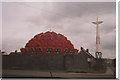
The Church of Christ the King, Bowburn in 1992
Known locally as the 'Pineapple Church'
Image: © Peter Robinson
Taken: Unknown
0.18 miles
6
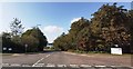
Entrance to Bowburn North Industrial Estate
Image: © Anthony Parkes
Taken: 22 Sep 2020
0.18 miles
7
Bowburn church
An interesting and very striking building but a flawed design and it was sadly demolished after standing empty for several years.
Image: © Helen Wilkinson
Taken: 13 Dec 2005
0.19 miles
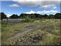
10
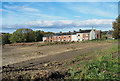
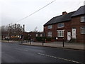
Terrace of houses at Bowburn
The terrace as viewed from a public footpath which at the time had been closed by the local authority because of the obvious groundwork being done for the 'Integra 61' Development. There was far more of it behind the camera position with heavy machinery manoeuvring. Another adjacent path was also closed. There was no warning of the path closures as an approach was made to them from the west and so the decision was made to press on through the works as not to, would have involved a significant retracing of steps.
Image: © Trevor Littlewood
Taken: 9 Oct 2018
0.24 miles