IMAGES TAKEN NEAR TO
Blackiston Close, DH6 4SX
Introduction
This page details the photographs taken nearby to Blackiston Close, DH6 4SX by members of the Geograph project.
The Geograph project started in 2005 with the aim of publishing, organising and preserving representative images for every square kilometre of Great Britain, Ireland and the Isle of Man.

There are currently over 7.5m images from over14,400 individuals and you can help contribute to the project by visiting https://www.geograph.org.uk
Image Map
Images are licensed for reuse under creativecommons.org/licenses/by-sa/2.0
Notes
- Clicking on the map will re-center to the selected point.
- The higher the marker number, the further away the image location is from the centre of the postcode.
Image Listing (6 Images Found)
Images are licensed for reuse under creativecommons.org/licenses/by-sa/2.0
Image
Details
Distance
1
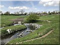
New drainage into Coxhoe Beck
A new drainage channel crossing fields to an outflow into Coxhoe beck, constructed in association with new housing on the southern edge of the village.
Image: © David Robinson
Taken: 30 Apr 2022
0.13 miles
2
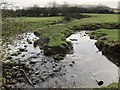
Coxhoe Beck
A 180 degree meander of Coxhoe Beck in fields to the South of the village.
Image: © David Robinson
Taken: 21 Jan 2019
0.16 miles
3
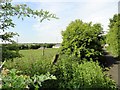
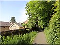
View south from the path to Bogma Hall Farm
This lane is at the south end of Coxhoe village. The farm outbuildings can be seen on the right.
Image: © Robert Graham
Taken: 19 Jun 2013
0.18 miles
4
Bogma Hall Farm, Coxhoe
Farm at the south end of the village.
Image: © Robert Graham
Taken: 19 Jun 2013
0.21 miles
5
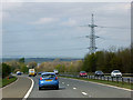
Powerlines crossing the A1(M) near to Cornforth
Image: © David Dixon
Taken: 29 Apr 2019
0.24 miles