IMAGES TAKEN NEAR TO
Quarrington Heights, DURHAM, DH6 4GE
Introduction
This page details the photographs taken nearby to Quarrington Heights, DH6 4GE by members of the Geograph project.
The Geograph project started in 2005 with the aim of publishing, organising and preserving representative images for every square kilometre of Great Britain, Ireland and the Isle of Man.

There are currently over 7.5m images from over14,400 individuals and you can help contribute to the project by visiting https://www.geograph.org.uk
Image Map
Images are licensed for reuse under creativecommons.org/licenses/by-sa/2.0
Notes
- Clicking on the map will re-center to the selected point.
- The higher the marker number, the further away the image location is from the centre of the postcode.
Image Listing (11 Images Found)
Images are licensed for reuse under creativecommons.org/licenses/by-sa/2.0
Image
Details
Distance
4
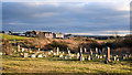
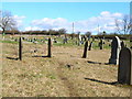
Graveyard at Quarrington Hill
The graveyard at Quarrington Hill is in what were the surroundings of St. Paul's Church which was demolished due to mining subsidence; the image was recorded from the original position of the church. Buildings at the northern end of the village are in view.
Image: © Trevor Littlewood
Taken: 30 Jan 2019
0.11 miles
7
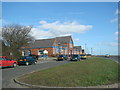
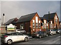
County Primary School, Quarrington Hill
Image: © Bill Henderson
Taken: 9 Mar 2007
0.18 miles
8
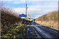
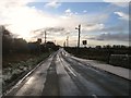
Road entering Quarrington from the south-east
The road is already alongside much of Quarrington which is to the left in the image, beyond the hedge. The road sign in blue with yellow trim and wording tells that the village is in County Durham.
Image: © Trevor Littlewood
Taken: 30 Jan 2019
0.20 miles
9
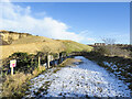
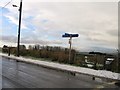
Bridleway heading towards Quarrington Hill
The bridleway, presumably an old industrial / mining route, connects Old Quarrington with Quarrington Hill. The route is in use a s a bridleway which has replaced another bridleway route running above to the left. That is now a private road used for quarry access by the Tarmac company.
OS mapping has not, (January 2022), caught up with the changed route situation; an explanation is given here: https://www.geograph.org.uk/photo/7063932 .
Image: © Trevor Littlewood
Taken: 7 Jan 2022
0.20 miles