IMAGES TAKEN NEAR TO
Railway Terrace North, HOUGHTON LE SPRING, DH4 7BB
Introduction
This page details the photographs taken nearby to Railway Terrace North, DH4 7BB by members of the Geograph project.
The Geograph project started in 2005 with the aim of publishing, organising and preserving representative images for every square kilometre of Great Britain, Ireland and the Isle of Man.

There are currently over 7.5m images from over14,400 individuals and you can help contribute to the project by visiting https://www.geograph.org.uk
Image Map
Images are licensed for reuse under creativecommons.org/licenses/by-sa/2.0
Notes
- Clicking on the map will re-center to the selected point.
- The higher the marker number, the further away the image location is from the centre of the postcode.
Image Listing (37 Images Found)
Images are licensed for reuse under creativecommons.org/licenses/by-sa/2.0
Image
Details
Distance

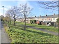
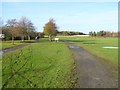
2

View of New Herrington from the Country Park
Looking through the trees to Railway Terrace, which used to house some of the miners who worked at Herrington Colliery. The country park was reclaimed from the colliery site between 1996 and 2002.
Image: © Robert Graham
Taken: 15 Aug 2023
0.05 miles
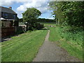
3
Cycle path running from Herrington Country Park
A road and cycle path follow the line of an old railway, backed on to by houses in Barnwell View.
Image: © Oliver Dixon
Taken: 15 Nov 2016
0.05 miles
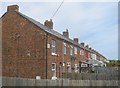
4
Terraced housing, Railway Terrace, New Herrington
Image: © JThomas
Taken: 28 May 2015
0.05 miles
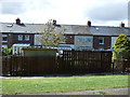
5

Old streets at New Herrington
This is Railway Terrace, a late 19th century terrace in the former pit village. It is now on the edge of Herrington Country Park; 200 hectares reclaimed from the site of Herrington Colliery.
Image: © Robert Graham
Taken: 15 Aug 2023
0.07 miles
6
Path behind Railway Terrace, New Herrington
Image: © JThomas
Taken: 28 May 2015
0.07 miles
8
A corner of Herrington Country Park
Established on the site of the old Herrington Colliery.
Image: © Oliver Dixon
Taken: 15 Nov 2016
0.08 miles
9
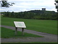
Herrington Country Park, near Sunderland
Herrington Country Park has been created on the site of a former colliery. The colliery closed in 1985.
The Penshaw Monument stands on a hilltop in the distance.
More information about the Herrington Country Park can be found on the websites of Sunderland City Council http://www.sunderland.gov.uk/index.aspx?articleid=2441 and Keep Britain Tidy http://www.keepbritaintidy.org/GreenFlag/GreenFlagAwardSites/NorthEast/Default.aspx?parkID=301
Image: © Malc McDonald
Taken: 29 Aug 2011
0.08 miles
10

Path in Herrington Country Park
Vie looking to the southwest. The 200 hectares of the restored mining site at Herrington has a network of paths running through it.
Image: © Robert Graham
Taken: 15 Aug 2023
0.09 miles