IMAGES TAKEN NEAR TO
Bournmoor, HOUGHTON LE SPRING, DH4 6EY
Introduction
This page details the photographs taken nearby to DH4 6EY by members of the Geograph project.
The Geograph project started in 2005 with the aim of publishing, organising and preserving representative images for every square kilometre of Great Britain, Ireland and the Isle of Man.

There are currently over 7.5m images from over14,400 individuals and you can help contribute to the project by visiting https://www.geograph.org.uk
Image Map
Images are licensed for reuse under creativecommons.org/licenses/by-sa/2.0
Notes
- Clicking on the map will re-center to the selected point.
- The higher the marker number, the further away the image location is from the centre of the postcode.
Image Listing (22 Images Found)
Images are licensed for reuse under creativecommons.org/licenses/by-sa/2.0
Image
Details
Distance

2
Day Will Come sculpture at Lambton Park
Image: © Peter Robinson
Taken: 11 Aug 2013
0.04 miles
3
Track to Biddick Hall
Looking north from Chester Road.
Image: © JThomas
Taken: 28 May 2015
0.12 miles
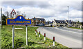
4
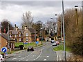
Chapel Row, Bournmoor
Bournmoor is a little former mining village near Fence Houses. It does have some nice old houses.
Image: © Robert Graham
Taken: 24 Apr 2013
0.12 miles
5
Chester Road (A183), Warping Bridge
Heading north east towards Sunderland.
Image: © JThomas
Taken: 28 May 2015
0.12 miles
6
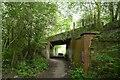
The Weardale Way passing beneath Wapping Bridge
The track bed of the former Leamside Railway crossed by the A183
Image: © Tim Heaton
Taken: 18 May 2023
0.13 miles
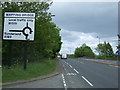
7
New housing development at Bournmoor
Bournmoor is a village in County Durham closely associated with the Lambton estate. The road passing the village sign is the A183 beyond which is new housing development on land of the Lambton estate.
Image: © Trevor Littlewood
Taken: 25 Apr 2023
0.14 miles
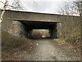
8
Wapping Bridge
Carries the A183 over the disused Leamside Railway - passed by on the Weardale Way.
Closed to all traffic by 1990, it ran from Tursdale Junction to the Durham Coast Line at Pelaw Junction.
There are discussions afoot, to a possible re-opening. Gravel stones on the trackbed appear to be in place.
Image: © Chris Heaton
Taken: 18 May 2023
0.14 miles
9
Disused railway trackbed at Bournmoor
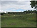
The former Leamside route was the original main line from Darlington - Newcastle before being relegated to a secondary route when the main line took the new route via Durham and Team Valley in 1872. By the 1980s the route was little used except when work on the main line required diversions, finally closing in 1991. Though the track is lifted the line retains a ‘mothballed’ status so has not been severed or built on, and is frequently proposed for reopening either as a heavy rail route or part of the Tyne and Wear Metro.
Image: © David Robinson
Taken: 14 Mar 2023
0.14 miles
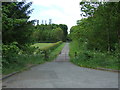
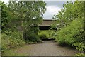
10

Path to Bibbick Woods
This path leads off Chester Road at Wapping Bridge, between the villages of Bournmoor and Shiney Row.
Image: © Robert Graham
Taken: 24 Apr 2013
0.14 miles