IMAGES TAKEN NEAR TO
Castle Dene, CHESTER LE STREET, DH3 4HE
Introduction
This page details the photographs taken nearby to DH3 4HE by members of the Geograph project.
The Geograph project started in 2005 with the aim of publishing, organising and preserving representative images for every square kilometre of Great Britain, Ireland and the Isle of Man.

There are currently over 7.5m images from over14,400 individuals and you can help contribute to the project by visiting https://www.geograph.org.uk
Image Map
Images are licensed for reuse under creativecommons.org/licenses/by-sa/2.0
Notes
- Clicking on the map will re-center to the selected point.
- The higher the marker number, the further away the image location is from the centre of the postcode.
Image Listing (21 Images Found)
Images are licensed for reuse under creativecommons.org/licenses/by-sa/2.0
Image
Details
Distance
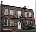
1
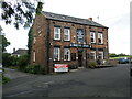
Smiths Arms, Forge Lane, Castle Dene, Near Chester-le-Street
Image: © Philip Soakell
Taken: 23 Jul 2009
0.02 miles
2
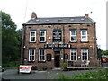
Smiths Arms, Forge Lane, Castle Dene, Near Chester-le-Street
Image: © Philip Soakell
Taken: 23 Jul 2009
0.02 miles
3
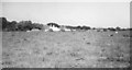
Lumley Forge Farm, 1968
A view of buildings at Brecon Hill from the B1284. Behind the farm buildings is the Smith's Arms, once the Blacksmith's Arms. The woodland beyond drops into Lumley Dene.
Image: © Derek Harper
Taken: Unknown
0.03 miles
5
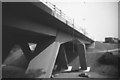
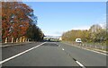
Lumley Dene Bridge, A1(M), before opening, 1968
The bridge across the Lumley Park Burn Dene has been completed but awaits opening. See also Image "Lumley Dene Bridge crosses a deep, steep-sided valley of considerable natural beauty, and, in keeping with this setting, the motorway is carried by this shaped steel arch which soars from 80 ft. above the valley floor. The three-pinned arch has a span of 191 ft. between springing points, and two spans simply supported between the "knees" of the arch and abutments on either side increase the total span to 330 ft. Both the arch and the side spans are of structural steelwork, acting compositely with reinforced concrete deck slabs, with separate structural systems provided for each carriageway" http://motorwayarchive.ihtservices.co.uk/en/motorways/motorway-listing/a1m/a1m-durham-motorway/index.cfm .
This stretch of the motorway was opened in September 1969, over a year after this photo was taken.
Image: © Derek Harper
Taken: Unknown
0.06 miles
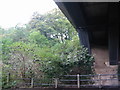
7
Beneath the A1 (M)
The A1 (M) crossing Lumley Park Burn and Forge Lane. Repair work can be seen taking place on Forge Lane where it crosses the burn.
Image: © David Robinson
Taken: 14 Mar 2023
0.10 miles
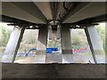
8
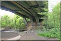
Beneath Lumley Dean Bridge
The A1(M) spanning Lumley Park Burn and Forge Lane. See the bridge just after construction in 1968 Image
Image: © Tim Heaton
Taken: 18 May 2023
0.11 miles
9
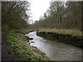
Breckon Hill
Photo taken while walking along the rivers foot path
Image: © Eric Haswell
Taken: 26 Mar 2006
0.13 miles