IMAGES TAKEN NEAR TO
Albert Street, CHESTER LE STREET, DH2 3LS
Introduction
This page details the photographs taken nearby to Albert Street, DH2 3LS by members of the Geograph project.
The Geograph project started in 2005 with the aim of publishing, organising and preserving representative images for every square kilometre of Great Britain, Ireland and the Isle of Man.

There are currently over 7.5m images from over14,400 individuals and you can help contribute to the project by visiting https://www.geograph.org.uk
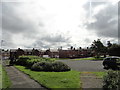
Image Map
Images are licensed for reuse under creativecommons.org/licenses/by-sa/2.0
Notes
- Clicking on the map will re-center to the selected point.
- The higher the marker number, the further away the image location is from the centre of the postcode.
Image Listing (32 Images Found)
Images are licensed for reuse under creativecommons.org/licenses/by-sa/2.0
Image
Details
Distance
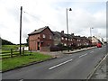
1
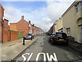
West Street, Grange Villa
View along this long terraced street. This ex-mining village consists mainly of a series of these streets, built for the miners in the early C20, before the Great War.
Image: © Robert Graham
Taken: 12 Aug 2019
0.03 miles
2
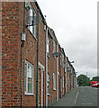
Satellite dishes
I am guessing that satellite is the only way of receiving digital TV in this small rural village. This is East Street, one of several similar terraces in Grange Villa.
Image: © Richard Dorrell
Taken: 26 Jul 2011
0.07 miles
3
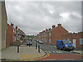
Queen Street, Grange Villa
Seen from its junction with Pelton Lane, this is one of several similar streets of small terraced houses in this rural ex-mining settlement.
Image: © Richard Dorrell
Taken: 26 Jul 2011
0.08 miles
4
Terraced rows in Grange Villa
A view of the rows of ex-miners houses in this little village near Chester le Street. These rows of early C20 terraces are very typical of the ex-mining villages in this part of Co Durham.
Image: © Robert Graham
Taken: 12 Aug 2019
0.08 miles
5
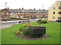
Unusual garden feature
A disused mine truck stands on a short section of rail and is now a feature in a small garden area of the ex-mining village of Grange Villa. The main road in the picture is Pelton Lane. On the right is East Street.
Image: © Richard Dorrell
Taken: 26 Jul 2011
0.10 miles
6
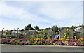
Roadside flower display at Grange Villa
A lovely display of colour in front of the allotments at Stone Row in this ex mining village.
Image: © Robert Graham
Taken: 16 Sep 2019
0.10 miles
7
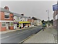
Bus at Grange Villa
This is the No 8 service going to Stanley from Chester le Street, operated by Go North East. The road is Pelton Lane, the villa main street with the shops etc. The ex-mining village of Grange Villa has a decent local bus service to the nearby towns.
Image: © Robert Graham
Taken: 12 Aug 2019
0.10 miles
8
Front Street, Grange Villa
The blue and yellow sign explains that the District Council is working towards a better district - here in Grange Villa with a regeneration scheme of rejuvenation and traffic calming. The most obvious new features are the paving of the walkways, the many bollards and the period style street lighting.
Image: © Richard Dorrell
Taken: 26 Jul 2011
0.10 miles
9
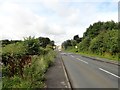
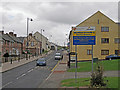
View up Pelton Lane to Grange Villa
This is the route into Grange Villa from the east, coming from Pelton Lane Ends.
Image: © Robert Graham
Taken: 12 Aug 2019
0.10 miles
10
Coronation Terrace, Grange Villa
This street must be named for the coronation of either Edward VII in 1902, or George V in 1911. I suspect it's the latter. The first houses in this old pit village were built in the 4th quarter of the C19, but most of the present village dates from the period between 1900 and the First World War. This view is along the main village street.
Image: © Robert Graham
Taken: 12 Aug 2019
0.10 miles