IMAGES TAKEN NEAR TO
Grange Villa Road, CHESTER LE STREET, DH2 2SR
Introduction
This page details the photographs taken nearby to Grange Villa Road, DH2 2SR by members of the Geograph project.
The Geograph project started in 2005 with the aim of publishing, organising and preserving representative images for every square kilometre of Great Britain, Ireland and the Isle of Man.

There are currently over 7.5m images from over14,400 individuals and you can help contribute to the project by visiting https://www.geograph.org.uk
Image Map
Images are licensed for reuse under creativecommons.org/licenses/by-sa/2.0
Notes
- Clicking on the map will re-center to the selected point.
- The higher the marker number, the further away the image location is from the centre of the postcode.
Image Listing (25 Images Found)
Images are licensed for reuse under creativecommons.org/licenses/by-sa/2.0
Image
Details
Distance
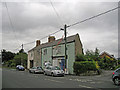
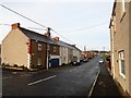
2
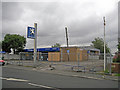
Out to grass?
This is the now deserted premises of a former Peugeot dealer in the rural village of Newfield. I suspect the business has moved to greener pastures.
Image: © Richard Dorrell
Taken: 26 Jul 2011
0.04 miles
3
The Hungry Hut
A roadside sandwich shop in the old mining village of Pelton Lane Ends.
Image: © Robert Graham
Taken: 12 Aug 2019
0.04 miles
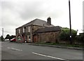
4
Hares Buildings, Pelton
A little terraced row in Pelton Lane Ends, a detached part of Pelton on the west side. It dates from the later part of the C19, and occupies a rather strange irregular site, as can be seen from the angle of the corner.
Image: © Robert Graham
Taken: 12 Aug 2019
0.05 miles
5
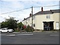
Shop in Newfield
For whatever reason, this building, now used as a shop, was built in a wedge shape, rather than the norm, with square corners.
Image: © Richard Dorrell
Taken: 26 Jul 2011
0.05 miles
6
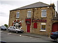
The Newfield Inn from the east
Viewed from Newfield Front Street. Newfield is a late 19th century mining village, which was probably when the pub was built.
Image: © Robert Graham
Taken: 14 Oct 2019
0.06 miles
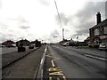
7
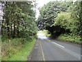
Looking down Pelton lane
View west along this country road which leads from Pelton Road Ends to Grange Villa.
Image: © Robert Graham
Taken: 12 Aug 2019
0.06 miles
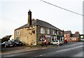
8
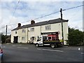
The Newfield Inn
In the village of Pelton Road Ends. It stands on Pelton Lane, at the junction with Newfild Road. Newfield village dates from the second half of the C19, as a pit village. The pub was built then also. The area around the pub is Pelton Lane Ends, another mining community, built at end of the C19 and the early C20. The building still has features from earlier times, for instance the arched opening in the outbuilding on the right, which was probably where the dray waggons went into the yard.
Image: © Robert Graham
Taken: 12 Aug 2019
0.06 miles
9
Looking west along the street in Newfield
This is Newfield Front Street, the main road through the village. View is to the junction with Pelton Road.
Image: © Robert Graham
Taken: 14 Oct 2019
0.07 miles
10
View down Newfield Road
In Pelton Lane Ends village. Looking east from the junction with Pelton Lane, with the Newfield Inn on the right. The car park used to be the site of Roseberry Comprehensive, which was closed in 2014 and demolished shortly afterwards.
Image: © Robert Graham
Taken: 12 Aug 2019
0.08 miles