IMAGES TAKEN NEAR TO
Staindrop Road, DURHAM, DH1 5XS
Introduction
This page details the photographs taken nearby to Staindrop Road, DH1 5XS by members of the Geograph project.
The Geograph project started in 2005 with the aim of publishing, organising and preserving representative images for every square kilometre of Great Britain, Ireland and the Isle of Man.

There are currently over 7.5m images from over14,400 individuals and you can help contribute to the project by visiting https://www.geograph.org.uk
Image Map
Images are licensed for reuse under creativecommons.org/licenses/by-sa/2.0
Notes
- Clicking on the map will re-center to the selected point.
- The higher the marker number, the further away the image location is from the centre of the postcode.
Image Listing (13 Images Found)
Images are licensed for reuse under creativecommons.org/licenses/by-sa/2.0
Image
Details
Distance
1

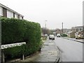
Canterbury Road, Newton Hall, Durham
Main road through housing estate.
Image: © wfmillar
Taken: 25 Dec 2013
0.09 miles
2

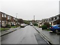
Canterbury Road, Newton Hall, Durham
Main Road through housing estate.
Image: © wfmillar
Taken: 25 Dec 2013
0.10 miles
4

Canterbury Road heading east
Canterbury Road is one of the main roads to pass through the large residential area of Newton Hall which is on the north side of Durham City.
Image: © Trevor Littlewood
Taken: 11 Sep 2015
0.12 miles
6

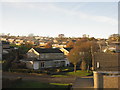
Newton Hall Estate
Newton Hall housing estate on the edge of Durham City was once the largest housing estate in Europe, developed mostly from the 1960s - 1980s.
Image: © David Robinson
Taken: 24 Jul 2019
0.15 miles
7
Housing estate, Newton Hall
Lindisfarne Road - part of an estate near Pity Me, north of Durham.
Image: © M J Richardson
Taken: 18 Nov 2019
0.15 miles
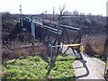
8
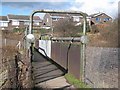
Railway footbridge at Newton Hall
This footbridge marks the far end of a useful and attractive path for cyclists and pedestrians running between Durham City Centre and the suburb of Newton Hall.
Image: © Oliver Dixon
Taken: 2 Mar 2007
0.17 miles
9
Railway footbridge, Newton Hall
This footbridge over the East Coast Main Line is the start of a useful, pleasant 2 km long cycle- and foot-path which links the suburb of Newton Hall with Durham City Centre.
Image: © Oliver Dixon
Taken: 2 Mar 2007
0.19 miles
10

Fields above Frankland Farm
Seen from the bridleway which carries the Weardale Way. Beyond the scrub-covered embankment which carries the East Coast Main Line is the suburb of Newton Hall.
Image: © Oliver Dixon
Taken: 18 Nov 2010
0.19 miles