IMAGES TAKEN NEAR TO
Nevilles Cross Bank, DURHAM, DH1 4JN
Introduction
This page details the photographs taken nearby to Nevilles Cross Bank, DH1 4JN by members of the Geograph project.
The Geograph project started in 2005 with the aim of publishing, organising and preserving representative images for every square kilometre of Great Britain, Ireland and the Isle of Man.

There are currently over 7.5m images from over14,400 individuals and you can help contribute to the project by visiting https://www.geograph.org.uk
Image Map
Images are licensed for reuse under creativecommons.org/licenses/by-sa/2.0
Notes
- Clicking on the map will re-center to the selected point.
- The higher the marker number, the further away the image location is from the centre of the postcode.
Image Listing (13 Images Found)
Images are licensed for reuse under creativecommons.org/licenses/by-sa/2.0
Image
Details
Distance
1
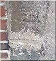
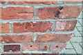
Ordnance Survey Cut Mark
This OS cut mark can be found on the gatepost of No4 Kells Terrace. It marks a point 78.242m above mean sea level.
Image: © Adrian Dust
Taken: 14 Sep 2018
0.10 miles
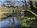
2
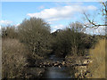
Pipeline over River Browney at Stonebridge
Stonebridge is a location on the outskirts of Durham City where there's a stone bridge and a pub of the same name. This view is from the A690 at a roundabout at Stonebridge, along the River Browney showing a pipeline crossing the river. The accumulated debris at the caging of the pipeline can surely only have been deposited there by the river being in flood; it would have been a remarkable sight!
Image: © Trevor Littlewood
Taken: 19 Sep 2010
0.12 miles
3
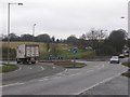
Stonebridge Roundabout on the A690
The main road from Crook and Willington to Durham city. Looking north-east towards Durham. The B6302 from Esh Winning comes in from the left.
Image: © Oliver Dixon
Taken: 17 Feb 2006
0.15 miles
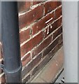
5
Ordnance Survey Cut Mark
This OS cut mark can be found on Ashville, Nevilles Cross Bank. It marks a point 88.084m above mean sea level.
Image: © Adrian Dust
Taken: 14 Sep 2018
0.18 miles
6
Ordnance Survey Cut Mark
This OS cut mark can be found on No9 Darlington Road. It marks a point 95.710m above mean sea level.
Image: © Adrian Dust
Taken: 14 Sep 2018
0.19 miles
7
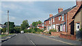
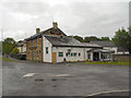
Lowe's Barn Bank, Durham
Towards the western edge of the Durham built up area.
Image: © Des Blenkinsopp
Taken: 27 Aug 2022
0.19 miles
9
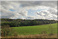
View east from East Coast Main Line
Across the field are trees along the River Browney.
Image: © Robin Webster
Taken: 18 Oct 2019
0.21 miles
10
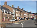
Dalton Crescent, Neville's Cross, Durham
A crescent of modern town houses, just off the former A1.
Image: © David Hawgood
Taken: 11 Sep 2016
0.22 miles