IMAGES TAKEN NEAR TO
Farnley Ridge, DURHAM, DH1 4HB
Introduction
This page details the photographs taken nearby to Farnley Ridge, DH1 4HB by members of the Geograph project.
The Geograph project started in 2005 with the aim of publishing, organising and preserving representative images for every square kilometre of Great Britain, Ireland and the Isle of Man.

There are currently over 7.5m images from over14,400 individuals and you can help contribute to the project by visiting https://www.geograph.org.uk
Image Map
Images are licensed for reuse under creativecommons.org/licenses/by-sa/2.0
Notes
- Clicking on the map will re-center to the selected point.
- The higher the marker number, the further away the image location is from the centre of the postcode.
Image Listing (41 Images Found)
Images are licensed for reuse under creativecommons.org/licenses/by-sa/2.0
Image
Details
Distance
1
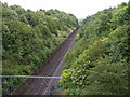
Battle Cutting
The railway on the approach to Durham Station as it cuts through the battle site of Neville's Cross, viewed from the Newcastle Road bridge.
Image: © Gordon Griffiths
Taken: 28 Jun 2008
0.07 miles
2
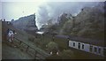
Flying Scotsman, Redhills Cutting, Durham, 1968
Taken a few moments after Image], with 4472 entering a cutting that is now much more wooded. Lots of camera clicking and children waving.
Image: © Derek Harper
Taken: 4 May 1968
0.11 miles
3
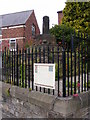
Old Wayside Cross by the A167, Durham parish
Neville's Cross, old base and stump of shaft, by the A167, in parish of Durham (Durham District), Crossgate, junction with A690, marking site of battle of Neville's Cross in 1346.
Grade II listed.
List Entry Number: 1323226 https://historicengland.org.uk/listing/the-list/list-entry/1323226
Scheduled Monument.
List Entry Number: 1016622 https://historicengland.org.uk/listing/the-list/list-entry/1016622
Surveyed
Milestone Society National ID: DUDU_DUR02
Image: © Milestone Society
Taken: Unknown
0.13 miles
4
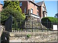
Neville's Cross
The Cross at the site of the 1346 battle on Crossgate Peth Durham.
Image: © Gordon Griffiths
Taken: 28 Jun 2008
0.13 miles
5
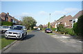
St Monica Grove, Crossgate Moor
National Cycle Route 14 heading east.
Image: © JThomas
Taken: 4 Jun 2016
0.14 miles
6
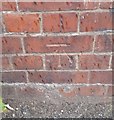
Ordnance Survey Cut Mark
This OS cut mark can be found on the NE parapet of the railway bridge, Newcastle Road. It marks a point 99.429m above mean sea level.
Image: © Adrian Dust
Taken: 14 Sep 2018
0.14 miles
7
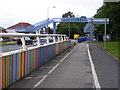
Newcastle Road Footbridge
The A167 at Neville's Cross.
Image: © Gordon Griffiths
Taken: 28 Jun 2008
0.14 miles
8
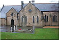
War Memorial, Neville's Cross
In front of St John's Church.
Image: © JThomas
Taken: 28 Nov 2015
0.15 miles
9
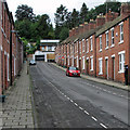
Durham: up May Street
Late 19th-century terraces and some modern infill at the top.
Image: © John Sutton
Taken: 2 Sep 2016
0.15 miles
10

Ordnance Survey Cut Mark
This OS cut mark can be found on the wall NW end of George Street. It marks a point 100.267m above mean sea level.
Image: © Adrian Dust
Taken: 14 Sep 2018
0.15 miles