IMAGES TAKEN NEAR TO
Cross Valley Court, DURHAM, DH1 4GD
Introduction
This page details the photographs taken nearby to Cross Valley Court, DH1 4GD by members of the Geograph project.
The Geograph project started in 2005 with the aim of publishing, organising and preserving representative images for every square kilometre of Great Britain, Ireland and the Isle of Man.

There are currently over 7.5m images from over14,400 individuals and you can help contribute to the project by visiting https://www.geograph.org.uk
Image Map
Images are licensed for reuse under creativecommons.org/licenses/by-sa/2.0
Notes
- Clicking on the map will re-center to the selected point.
- The higher the marker number, the further away the image location is from the centre of the postcode.
Image Listing (22 Images Found)
Images are licensed for reuse under creativecommons.org/licenses/by-sa/2.0
Image
Details
Distance
1

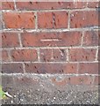
Ordnance Survey Cut Mark
This OS cut mark can be found on the wall NW end of George Street. It marks a point 100.267m above mean sea level.
Image: © Adrian Dust
Taken: 14 Sep 2018
0.06 miles
2
Neville's Cross
The Cross at the site of the 1346 battle on Crossgate Peth Durham.
Image: © Gordon Griffiths
Taken: 28 Jun 2008
0.09 miles
3
Ordnance Survey Cut Mark
This OS cut mark can be found on the NE parapet of the railway bridge, Newcastle Road. It marks a point 99.429m above mean sea level.
Image: © Adrian Dust
Taken: 14 Sep 2018
0.09 miles
4
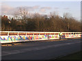
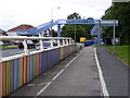
Newcastle Road (A167), Durham
This is where the A167 crosses the east coast main line. After the Selby rail disaster, the authorities, at no doubt enormous expense, put in crash barriers to guard against the highly unlikely event of runaway vehicles crashing down into the very deep cutting below. At first, the barriers were painted plain blue, but then somebody in authority decided to jazz them up a bit, so they are now very colourful indeed.
Image: © Oliver Dixon
Taken: 18 Feb 2006
0.09 miles
5
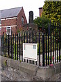
Old Wayside Cross by the A167, Durham parish
Neville's Cross, old base and stump of shaft, by the A167, in parish of Durham (Durham District), Crossgate, junction with A690, marking site of battle of Neville's Cross in 1346.
Grade II listed.
List Entry Number: 1323226 https://historicengland.org.uk/listing/the-list/list-entry/1323226
Scheduled Monument.
List Entry Number: 1016622 https://historicengland.org.uk/listing/the-list/list-entry/1016622
Surveyed
Milestone Society National ID: DUDU_DUR02
Image: © Milestone Society
Taken: Unknown
0.10 miles
6
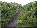
Battle Cutting
The railway on the approach to Durham Station as it cuts through the battle site of Neville's Cross, viewed from the Newcastle Road bridge.
Image: © Gordon Griffiths
Taken: 28 Jun 2008
0.11 miles
7
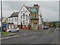
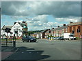
Michelangelo, Neville's Cross
The Michelangelo bar and ristorante at the Nevill'e Cross junction on the A167, Darlington Road.
Image: © David Dixon
Taken: 22 Jun 2011
0.11 miles
8
Newcastle Road Footbridge
The A167 at Neville's Cross.
Image: © Gordon Griffiths
Taken: 28 Jun 2008
0.11 miles
9
Neville's Cross Junction
The A167 at Neville's Cross Durham.
Image: © Gordon Griffiths
Taken: 28 Jun 2008
0.12 miles
10
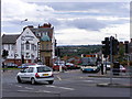
Junction of the A690 and A167
With Michelangelo's Bar and Restaurant to the left of the photo
Image: © Alexander P Kapp
Taken: 24 Jun 2011
0.12 miles