IMAGES TAKEN NEAR TO
Sutton Street, DURHAM, DH1 4DA
Introduction
This page details the photographs taken nearby to Sutton Street, DH1 4DA by members of the Geograph project.
The Geograph project started in 2005 with the aim of publishing, organising and preserving representative images for every square kilometre of Great Britain, Ireland and the Isle of Man.

There are currently over 7.5m images from over14,400 individuals and you can help contribute to the project by visiting https://www.geograph.org.uk
Image Map
Images are licensed for reuse under creativecommons.org/licenses/by-sa/2.0
Notes
- Clicking on the map will re-center to the selected point.
- The higher the marker number, the further away the image location is from the centre of the postcode.
Image Listing (288 Images Found)
Images are licensed for reuse under creativecommons.org/licenses/by-sa/2.0
Image
Details
Distance
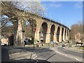
1
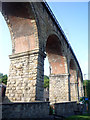
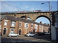
Durham: Sutton Street and the viaduct
Bright sunlight and deep shadows on a September morning. Flass Street climbs to the right.
Image: © John Sutton
Taken: 2 Sep 2014
0.01 miles
2
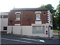
Working Mens Club & Institute Union LTD, Durham
On Flass Street.
Showing position of Postbox No. DH1 168.
See Image] for postbox.
Image: © JThomas
Taken: 4 Jun 2016
0.01 miles
3
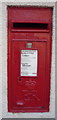
Elizabeth II postbox on Flass Street, Durham
Postbox No. DH1 168.
See Image] for context.
Image: © JThomas
Taken: 4 Jun 2016
0.02 miles
4
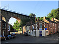
Railway viaduct over Sutton Street, Durham
CrossCountry train arriving into Durham Railway Station.
Image: © JThomas
Taken: 4 Jun 2016
0.02 miles
5

Flass Street and Waddington Street, Durham
Image: © Martin Speck
Taken: 26 Jun 2012
0.02 miles
6
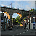
Durham: morning sunlight on the railway viaduct
Looking up Sutton Street shortly after seven o'clock on the first morning of September.
Image: © John Sutton
Taken: 1 Sep 2016
0.02 miles
7
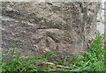
Ordnance Survey Cut Mark
This OS cut mark can be found at the base of viaduct pier east side of Sutton Street. It marks a point 52.825m above mean sea level.
Image: © Adrian Dust
Taken: 14 Sep 2018
0.02 miles
8
Durham: under the arches
Bridge Street and the corner of Lambton Street on a showery May morning. A northbound train is crossing the viaduct.
Image: © John Sutton
Taken: 11 May 2015
0.03 miles
9
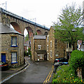
Durham Viaduct
Grade II listed railway viaduct, built 1857 for the North Eastern Railway's Durham - Bishop Auckland line. In 1871 the route from Tursdale Junction - Durham - Newcastle was developed and this became the main line from London - Newcastle replacing the route via Leamside. In 1987 the viaduct was cleaned of 130 years of smoke & grime that had built up from the city's housing and industry.
Image: © David Robinson
Taken: 27 Mar 2022
0.03 miles