IMAGES TAKEN NEAR TO
Red Hill, DURHAM, DH1 4BD
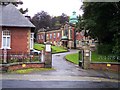
Introduction
This page details the photographs taken nearby to Red Hill, DH1 4BD by members of the Geograph project.
The Geograph project started in 2005 with the aim of publishing, organising and preserving representative images for every square kilometre of Great Britain, Ireland and the Isle of Man.

There are currently over 7.5m images from over14,400 individuals and you can help contribute to the project by visiting https://www.geograph.org.uk
Image Map (Loading...)


Getting Data...Please wait
Leaflet Map data © OpenStreetMap
Images are licensed for reuse under creativecommons.org/licenses/by-sa/2.0
Notes
- Clicking on the map will re-center to the selected point.
- The higher the marker number, the further away the image location is from the centre of the postcode.
Image Listing (182 Images Found)
Images are licensed for reuse under creativecommons.org/licenses/by-sa/2.0
Image
Details
Distance
1
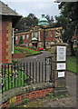
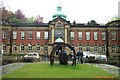
Durham Miners' Hall
The offices of the National Union of Mineworkers and also of the local Labour Party. The building dates from 1913-15 and is Grade II listed.
Image: © John Sutton
Taken: 2 Sep 2016
0.01 miles
2
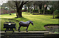
Grounds of Durham Miners? Hall
Durham Miners’ Hall and Grounds stand at the head of Flass Street, west of the city centre. With the demise of coal mining the need for such large administrative premises no longer exists and the building is shared with other organisations.
The pit pony sculpture and coal tub was "Created by young people of different abilities from all over County Durham".
Image: © Trevor Littlewood
Taken: 25 Jan 2016
0.03 miles
3
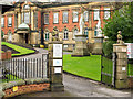
Gateway to Durham Miners' Hall
Durham Miners’ Hall and Grounds stand at the head of Flass Street, west of the city centre. With the demise of coal mining the need for such large administrative premises no longer exists and the building is shared with other organisations.
Two white statues can be seen inside; two others, also on plinths, stand out of sight. They are of individuals prominent in the history of the mine working trade unions; the four of them apparently stood in niches on the frontage of an earlier building.
Image: © Trevor Littlewood
Taken: 25 Jan 2016
0.03 miles
4
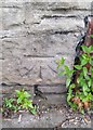
Ordnance Survey Cut Mark
This OS cut mark can be found on the wall NW side of Redhills Lane. It marks a point 26.161m above mean sea level.
Image: © Adrian Dust
Taken: 14 Sep 2018
0.04 miles
5
Durham NUM Headquarters
The former Headquarters of Durham Miners Union
Image: © derek dye
Taken: 4 May 2004
0.04 miles
6
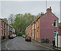
Durham: Mowbray Street
A cul-de-sac off Waddington Street.
Image: © John Sutton
Taken: 11 May 2015
0.05 miles
7
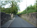
Redhills Lane
Heading east beside the East Coast Main Line.
Image: © JThomas
Taken: 4 Jun 2016
0.06 miles
8
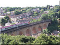
Virgin Voyager crossing Durham Viaduct
Virgin Voyager train heading south across Durham Viaduct on the East Coast Main Line. Taken from Wharton Park.
Image: © Adam Brookes
Taken: 23 Aug 2005
0.06 miles
10
Durham: The Bowers
New houses, in the local vernacular style, on the site of a bus depot. This estate was built in 2014 and Image] shows part of the site fence when work was in progress.
Image: © John Sutton
Taken: 11 May 2015
0.07 miles