IMAGES TAKEN NEAR TO
Church Street Head, DURHAM, DH1 3DN
Introduction
This page details the photographs taken nearby to Church Street Head, DH1 3DN by members of the Geograph project.
The Geograph project started in 2005 with the aim of publishing, organising and preserving representative images for every square kilometre of Great Britain, Ireland and the Isle of Man.

There are currently over 7.5m images from over14,400 individuals and you can help contribute to the project by visiting https://www.geograph.org.uk
Image Map
Images are licensed for reuse under creativecommons.org/licenses/by-sa/2.0
Notes
- Clicking on the map will re-center to the selected point.
- The higher the marker number, the further away the image location is from the centre of the postcode.
Image Listing (140 Images Found)
Images are licensed for reuse under creativecommons.org/licenses/by-sa/2.0
Image
Details
Distance
1
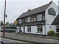
New Inn
An Inn on the Stockton Road
Image: © Gordon Griffiths
Taken: 20 Apr 2007
0.02 miles
3
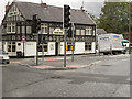
New Inn
The New Inn, at the corner of Stockton Road and South Road, Durham.
Image: © David Dixon
Taken: 22 Jun 2011
0.04 miles
4
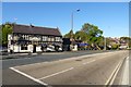
Stockton Road
The New Inn on the corner of Stockton Road and Church Street.
Image: © DS Pugh
Taken: 28 Aug 2014
0.04 miles
5
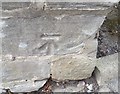
Ordnance Survey Cut Mark
This OS cut mark can be found on the wall NW side of Church Street Head. It marks a point 52.435m above mean sea level.
Image: © Adrian Dust
Taken: 14 Sep 2018
0.05 miles
6
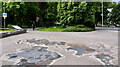
Pavement map in Durham city
This is close to the Bill Bryson Library at Durham University. It's a geological map of the UK and Ireland with rock types indicated by actual specimens cut to the necessary shape. It's not known whether for example the granite specimen for the Goat Fell area of Arran actually came from that location, or if 'generic' specimens were used.
Image: © Trevor Littlewood
Taken: 9 Jun 2024
0.06 miles
7
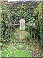
Old Wayside Cross on Quarryheads Lane in Durham
Charley's Cross, old base and stump of shaft by the UC road, in parish of Durham (Durham District), Northwest corner of the junction of Church Street Head and Quarryheads Lane, behind rails in hedge.
Grade II listed.
List Entry Number: 1121392 https://historicengland.org.uk/listing/the-list/list-entry/1121392
Surveyed
Milestone Society National ID: DUDU_DUR01
Image: © M Rayner
Taken: 1 Jul 2016
0.06 miles
8
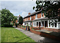
Gladstone Terrace
Gladstone Terrace on the north side of Stockton Road in Durham.
Quite a contrast of style in comparison to the Palatine Centre which is on the opposite side of the road; it's the building of Durham University's Law School: https://www.geograph.org.uk/photo/3157159 .
Image: © Trevor Littlewood
Taken: 9 Jun 2024
0.06 miles
9
Library, Science site, Durham University, 1968
It would now be impossible to take this view; the square building is now merely the north block of the Bill Bryson Library, which has grown to around four times the size. Something of the building which now occupies most of this lawn can be seen in Image On the left is a house on the other side of Stockton Road. On the right is Whinney Hill.
Image: © Derek Harper
Taken: Unknown
0.07 miles
10
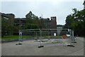
What Lies Beneath Us and Bill Bryson Library
Looking towards the Bill Bryson Library with the map artwork "What Lies Beneath" in front.
Image: © DS Pugh
Taken: 24 Aug 2023
0.08 miles