IMAGES TAKEN NEAR TO
Shincliffe Lane, DURHAM, DH1 2SH
Introduction
This page details the photographs taken nearby to Shincliffe Lane, DH1 2SH by members of the Geograph project.
The Geograph project started in 2005 with the aim of publishing, organising and preserving representative images for every square kilometre of Great Britain, Ireland and the Isle of Man.

There are currently over 7.5m images from over14,400 individuals and you can help contribute to the project by visiting https://www.geograph.org.uk
Image Map
Images are licensed for reuse under creativecommons.org/licenses/by-sa/2.0
Notes
- Clicking on the map will re-center to the selected point.
- The higher the marker number, the further away the image location is from the centre of the postcode.
Image Listing (12 Images Found)
Images are licensed for reuse under creativecommons.org/licenses/by-sa/2.0
Image
Details
Distance

2
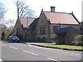
Sherburn House Dispensary - now occupied by the Kairos organisation
Image: © Roger Smith
Taken: 30 Mar 2008
0.04 miles
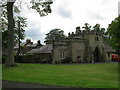
4
Sherburn Hospital, Sherburn House, Durham
Founded as "Christ's Hospital at Sherburn", the building stands in a secluded valley near Durham. The hamlet in which it is located is known as Sherburn House. It must surely have taken its name from that ancient foundation by Bishop Pudsey, who founded the original buildings for the recuperation of lepers about the year 1181-84. Originally, it housed 65 "poor brethren or lepers" and was reorganised by Bishop Langley in 1429, who reduced the number of residents to just fifteen.
The building is now a care home administered by the Sherburn House Charity and its various buildings have a chequered history. For more see http://www.durhamtimes.co.uk/history/pasttimes/4241286.Leper_hospital_was_prominent_site_in_village/ .
Image: © Alan Fearon
Taken: 7 Nov 2005
0.11 miles
5
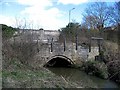
Sherburnhouse Bridge
Built 1335 on the route from Durham to Sherburn Hospital this medieval bridge is a scheduled ancient monument. It was replaced in 1930 by the present bridge, seen in the background, which carries the A181.
Image: © Roger Smith
Taken: 30 Mar 2008
0.13 miles
6
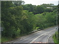
The A181 crossing Sherburnhouse Bridge
Image: © Peter Robinson
Taken: 12 Jul 2011
0.14 miles
7
Sherburnhouse bridge
Medieval bridge dating from 1335 though the upper part is from a later rebuild. Suffering from erosion, an at risk category A according to Historic England data here: https://historicengland.org.uk/advice/heritage-at-risk/search-register/list-entry/48744
Image: © David Robinson
Taken: 26 Nov 2018
0.14 miles
8
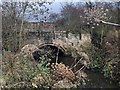
Footpath leading from Sherburn House to Sherburn
Image: © Roger Smith
Taken: 30 Mar 2008
0.16 miles
9
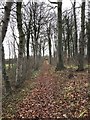
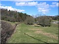
Footpath, Sherburn House
Footpath towards Whitwell Grange from Sherburn House. The path is on an embankment across the culverted Chapman Beck which was constructed as a waggonway taking coals from Cassop Vale. The waggonway pre-dates the Leamside line which it crosses at Whitwell and joined the line from Shincliffe village towards Sunderland. The junction later gained a third branch with the construction of the line to Durham Elvet. All these railways and waggonways are now closed.
Image: © David Robinson
Taken: 26 Nov 2018
0.20 miles