IMAGES TAKEN NEAR TO
Corse Hill, CASTLE DOUGLAS, DG7 3YE
Introduction
This page details the photographs taken nearby to Corse Hill, DG7 3YE by members of the Geograph project.
The Geograph project started in 2005 with the aim of publishing, organising and preserving representative images for every square kilometre of Great Britain, Ireland and the Isle of Man.

There are currently over 7.5m images from over14,400 individuals and you can help contribute to the project by visiting https://www.geograph.org.uk
Image Map
Images are licensed for reuse under creativecommons.org/licenses/by-sa/2.0
Notes
- Clicking on the map will re-center to the selected point.
- The higher the marker number, the further away the image location is from the centre of the postcode.
Image Listing (19 Images Found)
Images are licensed for reuse under creativecommons.org/licenses/by-sa/2.0
Image
Details
Distance
1
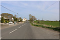
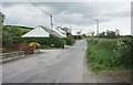
Houses on The Causey, Haugh of Urr
At the junction of Main Street (B794) and The Causey. Note the pre-Worboys signpost [http://www.geograph.org.uk/photo/5397873].
Image: © Richard Sutcliffe
Taken: 19 May 2017
0.07 miles
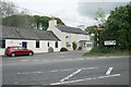
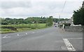
2
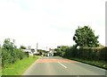
Road junction in Haugh of Urr
Main Street bears around to the left, The Causey goes to the right and Port Road is in the centre.
Image: © Ann Cook
Taken: 15 Sep 2012
0.08 miles
3
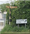
This way to Dalbeattie
Pre-Worboys and post-Worboys direction signs to Dalbeattie in Haugh of Urr. The pre-Worboys sign originally had three arms. Only two remain - pointing to Dalbeattie 3 1/2 MLS; and Haugh of Urr 1/4 ML. The third arm would have pointed down Port Street towards Hardgate (about half a mile north).
Image: © Richard Sutcliffe
Taken: 19 May 2017
0.08 miles
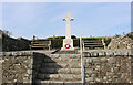
4
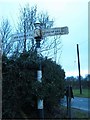
Old Direction sign - Signpost by the B794, Haugh of Urr
Spike finial - 2 arms; by the B794, in parish of Urr (Dumfries District), on corner at junction of The Causey with the B794.
Category B Listed by HES. Reference LB50003.
http://portal.historicenvironment.scot/designation/LB50003
Surveyed
Milestone Society National ID: DF_NX8166
Image: © Milestone Society
Taken: Unknown
0.08 miles
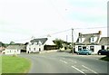
8
Main Street, Haugh of Urr
From the junction with Port Road and The Causey.
Image: © Richard Sutcliffe
Taken: 19 May 2017
0.11 miles