IMAGES TAKEN NEAR TO
DG2 8FB
Introduction
This page details the photographs taken nearby to DG2 8FB by members of the Geograph project.
The Geograph project started in 2005 with the aim of publishing, organising and preserving representative images for every square kilometre of Great Britain, Ireland and the Isle of Man.

There are currently over 7.5m images from over14,400 individuals and you can help contribute to the project by visiting https://www.geograph.org.uk
Image Map
Images are licensed for reuse under creativecommons.org/licenses/by-sa/2.0
Notes
- Clicking on the map will re-center to the selected point.
- The higher the marker number, the further away the image location is from the centre of the postcode.
Image Listing (11 Images Found)
Images are licensed for reuse under creativecommons.org/licenses/by-sa/2.0
Image
Details
Distance
1
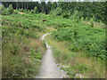
Mabie Forest - Descender Bender
Part of the Red Cycle Trail in Mabie Forest known as the ''Descender Bender'' the track is probably the most exciting part of the trail with fast sweeping downhill singletrack with loads of beams, burn splashes and a few camel bumps.
Image: © Andy Connor
Taken: 20 Jul 2008
0.11 miles
2
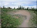
Berm, Descender Bender
One of the many banked corners (they are steep, intimidating but easy) on the Descender Bender descent on the Mabie red route.
Image: © Richard Webb
Taken: 23 May 2013
0.13 miles
3
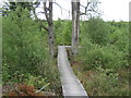
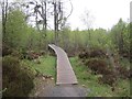
Mabie Forest - The Elevator
This Boardwalk marks the start of a long uphill section known as The Elevator on the Red Cycle Trail in Mabie Forest.
Image: © Andy Connor
Taken: 20 Jul 2008
0.16 miles
4
Mabie red route
Traversing the side of Marthrown Hill through young larch trees.
Image: © Richard Webb
Taken: 23 May 2013
0.17 miles
5
Boardwalk, Mabie Forest
The Elevator, a climb on the red mountainbike route.
Image: © Richard Webb
Taken: 23 May 2013
0.17 miles
6
Descender Bender
The long swooping descent of Woodhead Hill on the red trail at Mabie. The forest was quiet today and I saw nobody on my round.
Image: © Richard Webb
Taken: 23 May 2013
0.20 miles
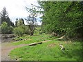
7
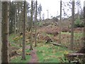
Windthrow, Mabie Forest
The red route passes a windthrown area on Marthrown Hill.
Image: © Richard Webb
Taken: 23 May 2013
0.20 miles
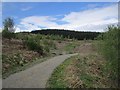
8
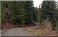
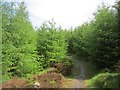
Road winding through Mabie Forest
The forestry road winds northwards along the south-western slope of Woodhead Hill, the highest point in Mabie Forest.
Image: © Trevor Littlewood
Taken: 13 Feb 2011
0.23 miles
9
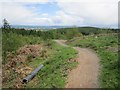
Logging road, Mabie
View from where the red MTB trail crosses, halfway down Descender Bender. There are areas of felled woodland here (this was once a runnable orienteering forest used for major championships) that have not been replanted and are turning into natural birch woods.
Image: © Richard Webb
Taken: 23 May 2013
0.23 miles
10
Marthrown of Woodhead
The exit from Descender Bender, a downhill section of the red mountainbike trail at Mabie. This is the site of a farm, Marthrown of Mabie. The buildings are shown on older Ordnance Survey maps, but there is no sign of them on a 1980 orienteering map.
Image: © Richard Webb
Taken: 23 May 2013
0.24 miles