IMAGES TAKEN NEAR TO
Wilson Avenue, HEANOR, DE75 7RU
Introduction
This page details the photographs taken nearby to Wilson Avenue, DE75 7RU by members of the Geograph project.
The Geograph project started in 2005 with the aim of publishing, organising and preserving representative images for every square kilometre of Great Britain, Ireland and the Isle of Man.

There are currently over 7.5m images from over14,400 individuals and you can help contribute to the project by visiting https://www.geograph.org.uk
Image Map
Images are licensed for reuse under creativecommons.org/licenses/by-sa/2.0
Notes
- Clicking on the map will re-center to the selected point.
- The higher the marker number, the further away the image location is from the centre of the postcode.
Image Listing (39 Images Found)
Images are licensed for reuse under creativecommons.org/licenses/by-sa/2.0
Image
Details
Distance
1
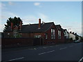
Loscoe-Denby Lane school
Now closed, this primary school has been relocated. Due for demolition and the building of new houses.
Image: © sheral wood
Taken: 13 Aug 2007
0.07 miles
2
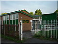
The Loscoe Evergreen Centre
This building is locally used by the Women's Institute.
Image: © sheral wood
Taken: 15 Aug 2007
0.11 miles
3
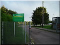
Charles Hill Leisure Centre
Entrance site to the sports field and leisure centre, located off Flamstead Avenue, Loscoe.
Image: © sheral wood
Taken: 15 Aug 2007
0.17 miles
4
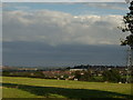
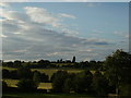
From Codnor Breach to Heanor
Standing on a Public footpath stile opposite Grammer Street, the town in the distance is Heanor.
Image: © sheral wood
Taken: 13 Aug 2007
0.17 miles
5
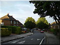
Flamstead Avenue Loscoe
Looking east and standing outside the entrance gates of Charles Hill Leisure Centre.
Image: © sheral wood
Taken: 15 Aug 2007
0.18 miles
6
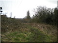
Footpath alongside Loscoe Brook west of Loscoe (1)
Heading towards Codnor Breach.
Image: © Richard Vince
Taken: 7 Mar 2020
0.19 miles
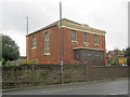
7
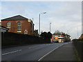
Loscoe Post Office
And general stores, and off-licence, on the corner of Loscoe Denby Lane and High Street.A chapel on the left.
Image: © Peter Barr
Taken: 17 Dec 2012
0.20 miles
8
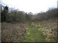
Footpath alongside Loscoe Brook west of Loscoe (2)
Winding its muddy way towards High Street, with a pylon standing sentinel over the scene.
Image: © Richard Vince
Taken: 7 Mar 2020
0.20 miles
9
August farmfields in Loscoe
This view taken on Loscoe-Denby Lane - to the right Loscoe, to the left Codnor Breach, not in view immediately in front is the children's playing swings etc.
Image: © sheral wood
Taken: 13 Aug 2007
0.20 miles
10
Loscoe Baptist Church
On the west side of the A6007 High Street. Built in 1722 as a Presbyterian dissenting chapel and changed to a Baptist chapel in 1782, when it became the first Baptist chapel in Derbyshire. Superb galleried interior.
Image: © Trevor Rickard
Taken: 28 Feb 2011
0.20 miles