IMAGES TAKEN NEAR TO
Croft Close, ILKESTON, DE7 4RQ
Introduction
This page details the photographs taken nearby to Croft Close, DE7 4RQ by members of the Geograph project.
The Geograph project started in 2005 with the aim of publishing, organising and preserving representative images for every square kilometre of Great Britain, Ireland and the Isle of Man.

There are currently over 7.5m images from over14,400 individuals and you can help contribute to the project by visiting https://www.geograph.org.uk
Image Map
Images are licensed for reuse under creativecommons.org/licenses/by-sa/2.0
Notes
- Clicking on the map will re-center to the selected point.
- The higher the marker number, the further away the image location is from the centre of the postcode.
Image Listing (47 Images Found)
Images are licensed for reuse under creativecommons.org/licenses/by-sa/2.0
Image
Details
Distance
1
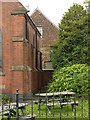
Glimpse of the abbey gatehouse
The building at the back of the old chapel is partly of medieval construction (the stone lower element) with 19th century brick construction on top. It was probably the gatehouse to Dale Abbey and is both Listed Grade II and a Scheduled Monument.
Image: © Alan Murray-Rust
Taken: 6 Aug 2017
0.04 miles
2
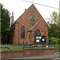
Gateway Centre, Dale Abbey
Former Methodist Chapel of 1902 now in use as Parish Rooms.
Image: © Alan Murray-Rust
Taken: 6 Aug 2017
0.05 miles
4
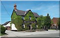
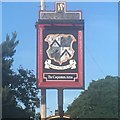
The Carpenters Arms in Dale Abbey
According to the fascinating village information board this pub was a venue for cock-fighting in the distant past.
Image: © Jonathan Clitheroe
Taken: 1 Jun 2013
0.05 miles
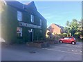
6
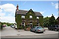
Carpenters Arms, Dale Abbey
Pub at the northern end of the village.
Image: © Dave Dunford
Taken: 22 Jun 2008
0.06 miles
7
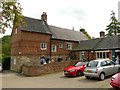
Poplar Farm, Dale Abbey
This is the rear of the house seen and described here http://www.geograph.org.uk/photo/5491153 .
This is the former farmyard, and some of the outbuildings have now been converted into a tea room.
Image: © Alan Murray-Rust
Taken: 6 Aug 2017
0.06 miles
8
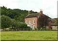
Abbey Farmhouse, Dale Abbey
Late 18th century farmhouse, Listed Grade II. There is probably no connection between the farm and the abbey other than its proximity to the ruins of the latter.
Image: © Alan Murray-Rust
Taken: 6 Aug 2017
0.06 miles
9
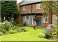
An English country garden
Not the same varieties of flower as mentioned in the song, but including Hydrangea, Montbretia, Allium, Pelargoniums, Fuchsia and Pinks. The garden of Poplar Farm http://www.geograph.org.uk/photo/5491153 .
Image: © Alan Murray-Rust
Taken: 6 Aug 2017
0.06 miles
10
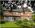
Poplar Farm, Dale Abbey
Listed by Historic England as Friar's House, the stone elements of the ground floor to the right date from the 15th century and would have been part of the abbey buildings. The upper storey of this section is early 18th century. The left hand, timber framed, section dates back to the 17th century (Listing description) or even earlier (Derbyshire HER record http://www.heritagegateway.org.uk/Gateway/Results_Single.aspx?uid=MDR10775&resourceID=1023 ). Listed Grade II.
Image: © Alan Murray-Rust
Taken: 6 Aug 2017
0.06 miles