
IMAGES TAKEN NEAR TO
Condor Road, ILKESTON, DE7 4RE
Introduction
This page details the photographs taken nearby to Condor Road, DE7 4RE by members of the Geograph project.
The Geograph project started in 2005 with the aim of publishing, organising and preserving representative images for every square kilometre of Great Britain, Ireland and the Isle of Man.

There are currently over 7.5m images from over14,400 individuals and you can help contribute to the project by visiting https://www.geograph.org.uk
Image Map
Images are licensed for reuse under creativecommons.org/licenses/by-sa/2.0
Notes
- Clicking on the map will re-center to the selected point.
- The higher the marker number, the further away the image location is from the centre of the postcode.
Image Listing (21 Images Found)
Images are licensed for reuse under creativecommons.org/licenses/by-sa/2.0
Image
Details
Distance
1
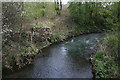
The Nut Brook
This shows the brook as it emerges from under Quarry Hill Road. Looking down stream towards the bridge in Image with the industrial estate through the trees straight ahead.
Image: © Kate Jewell
Taken: 22 Apr 2008
0.08 miles
2
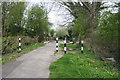
Footpath by Quarry Hill Road
This is an access footpath to the Nutbrook Trail. Walk up here and you leave the peace of the trail behind and re-enter the busy world. The Nut Brook passes under the path just past the black and white posts.
Image: © Kate Jewell
Taken: 22 Apr 2008
0.09 miles
3
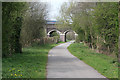
Road bridge over the Nutbrook Trail
This bridge carries Quarry Hill Road over the cycleway. Quarry Hill Industrial Estate is behind the trees on the right and the disused Nutbrook Canal and the now wooded brownfield site of the Stanton Ironworks is to the left. Straight ahead the trail heads towards Kirk Hallam and Ilkeston.
Image: © Kate Jewell
Taken: 22 Apr 2008
0.11 miles
4
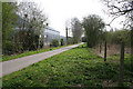
The Nutbrook Trail
Looking towards Long Eaton. This cycleway and Long Distance Path extends 9 miles between Long Eaton and Shipley Country Park. This stretch that follows a dismantled railway passes between the old Stanton Ironwork site on the right and the Quarry Hill Industrial Estate on the left.
Image: © Kate Jewell
Taken: 22 Apr 2008
0.12 miles
5
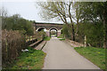
Two bridges
In the foreground the Nutbrook Trail goes over its namesake, the Nut Brook. Quarry Hill Road is carried over the trail on the bridge beyond.
Image: © Kate Jewell
Taken: 22 Apr 2008
0.12 miles
7
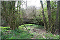
Old concrete bridge
An old bridge over the Nut Brook left over from the major industrial activity on this site in the 20th century. The disused Nutbrook Canal is just through the trees beyond.
Image: © Kate Jewell
Taken: 22 Apr 2008
0.13 miles
8
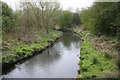
A loop in the brook
The Nut Brook makes a sharp meander after it passes under the Nutbrook Trail. The disused Nutbrook Canal is hidden in the trees in the distance.
Image: © Kate Jewell
Taken: 22 Apr 2008
0.13 miles
9
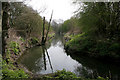
The Nut Brook
Looking down stream. The Nutbrook Trail is behind the trees on the left.
Image: © Kate Jewell
Taken: 22 Apr 2008
0.13 miles
10
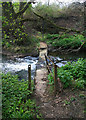
Pedestrian crossing over the Nut Brook
This metal footbridge used to link one side of the vast Stanton Ironworks site to the other. It has collapsed in centre stream causing the water to back up behind debris caught in its structure.
Image: © Kate Jewell
Taken: 22 Apr 2008
0.15 miles