IMAGES TAKEN NEAR TO
Orly Avenue, DERBY, DE74 2ND
Introduction
This page details the photographs taken nearby to Orly Avenue, DE74 2ND by members of the Geograph project.
The Geograph project started in 2005 with the aim of publishing, organising and preserving representative images for every square kilometre of Great Britain, Ireland and the Isle of Man.

There are currently over 7.5m images from over14,400 individuals and you can help contribute to the project by visiting https://www.geograph.org.uk
Image Map
Images are licensed for reuse under creativecommons.org/licenses/by-sa/2.0
Notes
- Clicking on the map will re-center to the selected point.
- The higher the marker number, the further away the image location is from the centre of the postcode.
Image Listing (103 Images Found)
Images are licensed for reuse under creativecommons.org/licenses/by-sa/2.0
Image
Details
Distance
1
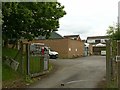
Castle Donington telephone exchange
Typical 1960s/70s exchange.
Image: © Alan Murray-Rust
Taken: 18 Jun 2019
0.08 miles
2
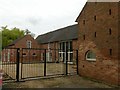
Outbuildings at 15 High Street, Castle Donington
Former farmyard range, now modernised, comprising barn (c.1700, rebuilt 18th century) stables and maltings. Listed Grade II.
Image: © Alan Murray-Rust
Taken: 18 Jun 2019
0.08 miles
3
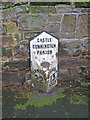
Milepost at Castle Donington
Mid 19th century cast iron milepost situated on High Street and reading 'Castle Donnington Parish' at the top, 'Tamworth 22 Miles' on the left and 'Nottingham 13 Miles' on the right. The oval plaque at the centre shows the makers to be Wootton Bros of Coalville. Note the village name has a double 'n'. In the 19th century Castle Donington was situated on the main Nottingham to Birmingham trunk road, so the mileposts were very important.
Image: © Trevor Rickard
Taken: 23 Jan 2011
0.08 miles
4
Outbuildings at 15 High Street, Castle Donington
Former farmyard range, now modernised, comprising barn (c.1700, rebuilt 18th century) stables and maltings. Listed Grade II. This is the face to High Street itself, the main ridge being the old barn, and the lower wing a later 19th century addition.
Image: © Alan Murray-Rust
Taken: 18 Jun 2019
0.09 miles
5
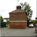
Dovecote off Delven Lane, Castle Donington
Early/mid 18th century, brick with diaper patterning, Listed Grade II. Originally related to Hall Farm.
Image: © Alan Murray-Rust
Taken: 18 Jun 2019
0.09 miles
6
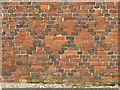
Dovecote off Delven Lane, Castle Donington
Well preserved diaper brickwork on the western face. See http://www.geograph.org.uk/photo/6188158 for location.
Image: © Alan Murray-Rust
Taken: 18 Jun 2019
0.09 miles
7
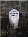
Milepost, High Street, Castle Donington
Apparently recently repainted to highlight the name of the parish (now spelled differently) and to obscure the mileages that indicate that this was once the main road between Nottingham and Tamworth (and thence Birmingham).
Image: © Richard Vince
Taken: 24 Nov 2018
0.09 miles
8
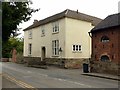
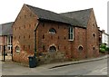
15 High Street, Castle Donington
Essentially an early 19th century house, although it may have 17th century origins, indicated by the stone plinth. Listed Grade II.
Image: © Alan Murray-Rust
Taken: 18 Jun 2019
0.10 miles
9
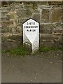
Milestone, High Street, Castle Donington
On the former turnpike road between Nottingham and Tamworth, thence to Birmingham. Listed Grade II.
The most recent paint job has painted over old paintwork, and has ignored the mileages, although these show up quite well with the accumulated muck. Note the double-N in the spelling of Donnington. The current spelling appears to have been regularised by the Ordnance Survey as the name already appears with just a single N on the first edition of the 1-inch series.
Image: © Alan Murray-Rust
Taken: 18 Jun 2019
0.10 miles
10
34 High Street, Castle Donington
Formerly a lodge to The Cedars http://www.geograph.org.uk/photo/6188110 . Early 19th century in Gothick style with traceried windows in rendered brick. Listed Grade II.
Image: © Alan Murray-Rust
Taken: 18 Jun 2019
0.11 miles