IMAGES TAKEN NEAR TO
Buttonoak Drive, DERBY, DE73 6PE
Introduction
This page details the photographs taken nearby to Buttonoak Drive, DE73 6PE by members of the Geograph project.
The Geograph project started in 2005 with the aim of publishing, organising and preserving representative images for every square kilometre of Great Britain, Ireland and the Isle of Man.

There are currently over 7.5m images from over14,400 individuals and you can help contribute to the project by visiting https://www.geograph.org.uk
Image Map
Images are licensed for reuse under creativecommons.org/licenses/by-sa/2.0
Notes
- Clicking on the map will re-center to the selected point.
- The higher the marker number, the further away the image location is from the centre of the postcode.
Image Listing (12 Images Found)
Images are licensed for reuse under creativecommons.org/licenses/by-sa/2.0
Image
Details
Distance
1
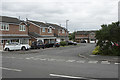
Blakebrook Drive
Blakebrook Drive is one of the many cul-de-sacs that are off Sutton Avenue in Chellaston.
Image: © Malcolm Neal
Taken: 2 Aug 2017
0.05 miles
2
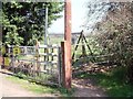
Footpath from Back Lane to Field Lane
Image: © Ian Calderwood
Taken: 28 Mar 2012
0.07 miles
3
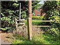
Footpath through a housing estate to Field Lane
Since I took Image in 2012, the Chellaston end of the footpath to Field Lane has been incorporated into a housing estate. The path now runs on the near side of the fence and is a surfaced pavement. This process is continuing out onto Boulton Moor as much of it disappears under housing.
Image: © Ian Calderwood
Taken: 29 Sep 2023
0.07 miles
5
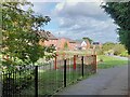
The site of Boulton Edge Farm
Since I took Image in 2012, Boulton Edge Farm has been swallowed by the houses of Chellaston, as it advances across Boulton Moor. The farmhouse was roughly where the drainage swale is.
Image: © Ian Calderwood
Taken: 29 Sep 2023
0.08 miles
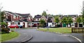
6
Maple Drive, Chellaston
Part of the late 20th suburban expansion of Derby.
Image: © Alan Murray-Rust
Taken: 14 Aug 2013
0.08 miles
7
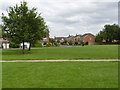
Graham Close
An area of open space incorporated into the Maple Drive estate.
Image: © Alan Murray-Rust
Taken: 14 Aug 2013
0.10 miles
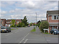
9
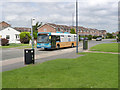
Bus service 60 on Maple Drive
The successor to the former Derby Corporation trolleybus route which terminated at Shelton Lock - well before this estate was built.
Image: © Alan Murray-Rust
Taken: 14 Aug 2013
0.13 miles
10
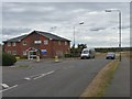
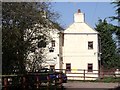
The Meadowfields Practice, Chellaston, Derby
This health centre is situated at the current end of Fellowlands Way. No doubt this road will extend farther into Boulton Moor when housing demand picks up again.
Image: © Richard Green
Taken: 21 Aug 2011
0.18 miles