IMAGES TAKEN NEAR TO
Main Road, ALFRETON, DE55 4NW
Introduction
This page details the photographs taken nearby to Main Road, DE55 4NW by members of the Geograph project.
The Geograph project started in 2005 with the aim of publishing, organising and preserving representative images for every square kilometre of Great Britain, Ireland and the Isle of Man.

There are currently over 7.5m images from over14,400 individuals and you can help contribute to the project by visiting https://www.geograph.org.uk
Image Map
Images are licensed for reuse under creativecommons.org/licenses/by-sa/2.0
Notes
- Clicking on the map will re-center to the selected point.
- The higher the marker number, the further away the image location is from the centre of the postcode.
Image Listing (55 Images Found)
Images are licensed for reuse under creativecommons.org/licenses/by-sa/2.0
Image
Details
Distance
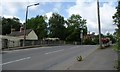
1
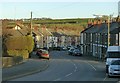
Pye Bridge
The community consists of little more than these terraces lining the B600.
Image: © Alan Murray-Rust
Taken: 30 Nov 2018
0.01 miles
2
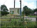
A future for the Erewash at Pye Bridge
Alongside the track to the sewage works, Severn Trent Water have erected a sign publicising their work to improve the River Erewash.
Image: © Christine Johnstone
Taken: 19 Aug 2017
0.01 miles
3
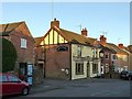
Do and Doublet, Pye Bridge
Despite the missing fascia which gives it a slightly forlorn air, the pub is still open for business.
Image: © Alan Murray-Rust
Taken: 30 Nov 2018
0.03 miles
4
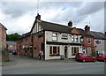
The Dog and Doublet pub, Pye Bridge
On the north side of Main Road [the B600].
Image: © Christine Johnstone
Taken: 19 Aug 2017
0.03 miles
5
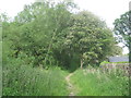
Footpath from Riddings to Pinxton
Near Pye Bridge.
Image: © Jonathan Thacker
Taken: 30 May 2012
0.05 miles
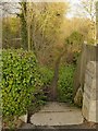
6

Steps up to the Main Road, Pye Bridge
From a public footpath on the towpath of the former Pinxton Arm [Cromford Canal].
Image: © Christine Johnstone
Taken: 19 Aug 2017
0.05 miles
7
Pinxton Canal Footpath at Pye Bridge
The steps down indicate the lower level of the canal compared with the road crossing it.
Image: © Alan Murray-Rust
Taken: 30 Nov 2018
0.05 miles
8
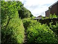
Footpath on the former Pinxton Arm of the Cromford Canal
Former towpath heading north from Pye Bridge. Before the railways, this canal was the main freight route in and out of the area. In the 1830s canal boats took coal from Pye Bridge to the River Trent and pig iron to Nottingham. They brought to Pye Bridge cargoes as diverse as timber from Leicester, hay from Derby, flour from the River Trent and corn from Nottingham. [Volunteers at the Friends of the Cromford Canal are creating a database from the original toll receipts.]
Image: © Christine Johnstone
Taken: 19 Aug 2017
0.05 miles
9
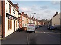
Main Road in Pye Bridge
Looking east from a position near the Dog and Doublet Public House which can be seen on the left. Pye Hill, also in this grid square can be seen in the distance.
Image: © Jonathan Clitheroe
Taken: 16 Feb 2013
0.05 miles
10
The bridge at Pye Bridge
Carrying Main Road [B600] over the Pinxton Arm of the Cromford Canal. Before the railways, this canal was the main freight route in and out of the area. In the 1830s canal boats took coal from Pye Bridge to the River Trent and pig iron to Nottingham. They brought to the wharf here cargoes as diverse as timber from Leicester, hay from Derby, flour from the River Trent and corn from Nottingham. [Volunteers at the Friends of the Cromford Canal are creating a database from the original toll receipts.]
Image: © Christine Johnstone
Taken: 19 Aug 2017
0.05 miles