IMAGES TAKEN NEAR TO
Bridle Lane, RIPLEY, DE5 3RQ
Introduction
This page details the photographs taken nearby to Bridle Lane, DE5 3RQ by members of the Geograph project.
The Geograph project started in 2005 with the aim of publishing, organising and preserving representative images for every square kilometre of Great Britain, Ireland and the Isle of Man.

There are currently over 7.5m images from over14,400 individuals and you can help contribute to the project by visiting https://www.geograph.org.uk
Image Map
Images are licensed for reuse under creativecommons.org/licenses/by-sa/2.0
Notes
- Clicking on the map will re-center to the selected point.
- The higher the marker number, the further away the image location is from the centre of the postcode.
Image Listing (33 Images Found)
Images are licensed for reuse under creativecommons.org/licenses/by-sa/2.0
Image
Details
Distance
1
Pipe bridge, Lower Hartshay
This strange structure becomes less so when you understand that this is the course of the old Cromford Canal, now filled in here. The road bridge has disappeared but the sewer pipe retains its original shape.
Image: © Alan Murray-Rust
Taken: 18 Mar 2009
0.01 miles
2
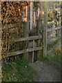
Towpath stile
Simple stile in the footpath with follows the towpath line of the former Cromford Canal. The thin vertical slides up to provide passage for larger dogs.
Image: © Alan Murray-Rust
Taken: 18 Mar 2009
0.03 miles
3
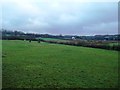
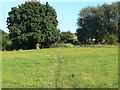
Fields at Lower Hartshay
Livestock grazing in a field bordering the disused Cromford Canal.
Image: © Jonathan Clitheroe
Taken: 22 Nov 2014
0.05 miles
4
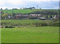
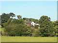
Lower Hartshay Hamlet
Lower Hartshay is a small rural settlement bypassed in the early 1970s by the new A610 bypass. It can now only be accessed by road, via the A610.
Image: © Nikki Mahadevan
Taken: 17 Apr 2006
0.06 miles
5

Stile at Lower Hartshay
This is on the towpath walk along the old Cromford Canal, which at this point has been filled in - the green area to the left is the bed; even the stile is probably within the cut itself.
Image: © Alan Murray-Rust
Taken: 18 Mar 2009
0.06 miles
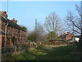
6
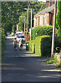
Bridle Lane, Lower Hartshay
The terraced cottages look a bit incongruous in the middle of an agricultural landscape, but in fact there were a number of collieries in the area in the 19th century.
Image: © Alan Murray-Rust
Taken: 19 Aug 2009
0.06 miles
7
Line of canal
The footpath follows the line of the towpath of the old Cromford canal which has completely vanished just here. It reappears in stages the other side of the fence.
Image: © Alan Murray-Rust
Taken: 19 Aug 2009
0.06 miles
8
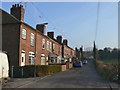
Bridle Lane, Lower Hartshay
The presence of this row of typically industrial cottages in a rural setting appears strange today, but in the 19th century there was considerable coal mining activity locally.
Image: © Alan Murray-Rust
Taken: 18 Mar 2009
0.07 miles
9
Lower Hartshay
Seen from the footpath which follows the line of the old Cromford Canal.
Image: © Alan Murray-Rust
Taken: 19 Aug 2009
0.09 miles
10
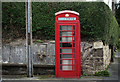
Red telephone box, Lower Hartshay
Introduced in 1936, the K6 telephone box was designed to commemorate the silver jubilee of King George V. This well preserved example is adjacent to the George Inn at Lower Hartshay. A different George of course.
Image: © Martin Froggatt
Taken: 21 Oct 2017
0.12 miles