IMAGES TAKEN NEAR TO
FORFAR, DD8 3NP
Introduction
This page details the photographs taken nearby to DD8 3NP by members of the Geograph project.
The Geograph project started in 2005 with the aim of publishing, organising and preserving representative images for every square kilometre of Great Britain, Ireland and the Isle of Man.

There are currently over 7.5m images from over14,400 individuals and you can help contribute to the project by visiting https://www.geograph.org.uk
Image Map
Images are licensed for reuse under creativecommons.org/licenses/by-sa/2.0
Notes
- Clicking on the map will re-center to the selected point.
- The higher the marker number, the further away the image location is from the centre of the postcode.
Image Listing (6 Images Found)
Images are licensed for reuse under creativecommons.org/licenses/by-sa/2.0
Image
Details
Distance
1
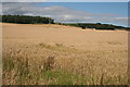
Baggerton
The crop in this field at Baggerton is wheat. The house just visible right of centre is Carsebank Cottages
Image: © Anne Burgess
Taken: 8 Aug 2007
0.11 miles
2
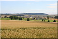
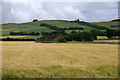
Carsebank
Wheat fields at Carsebank, and in the middle distance is Laird's plant at Lunanhead, which produces all manner of concrete products. Fothringham Hill is on the skyline.
Image: © Anne Burgess
Taken: 8 Aug 2007
0.13 miles
3
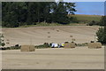
Fields near Carsebank
Telephone engineers working on the lines in the area.
Image: © Mary Rodgers
Taken: 3 Sep 2020
0.19 miles
6
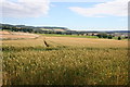
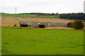
Carsebank
Wheat at varying stages of ripening at Carsebank. Dunnichen Hill in the distance.
Image: © Anne Burgess
Taken: 8 Aug 2007
0.23 miles