IMAGES TAKEN NEAR TO
Smieton Court, CARNOUSTIE, DD7 7NF
Introduction
This page details the photographs taken nearby to Smieton Court, DD7 7NF by members of the Geograph project.
The Geograph project started in 2005 with the aim of publishing, organising and preserving representative images for every square kilometre of Great Britain, Ireland and the Isle of Man.

There are currently over 7.5m images from over14,400 individuals and you can help contribute to the project by visiting https://www.geograph.org.uk
Image Map
Images are licensed for reuse under creativecommons.org/licenses/by-sa/2.0
Notes
- Clicking on the map will re-center to the selected point.
- The higher the marker number, the further away the image location is from the centre of the postcode.
Image Listing (21 Images Found)
Images are licensed for reuse under creativecommons.org/licenses/by-sa/2.0
Image
Details
Distance

2
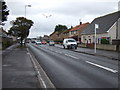
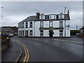
Barry Road (A930), Carnoustie
Heading east.
Image: © JThomas
Taken: 23 Oct 2013
0.08 miles
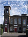
7
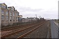
Railway, Carnoustie
Passing the Laing offices.
Image: © Richard Webb
Taken: 12 Mar 2016
0.17 miles
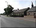
8
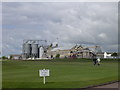
Carnoustie golf course with industrial 'backdrop'
Landward of the golf course is the main east coast railway line and the Carnoustie maltings (closed in 2004) with its distinctive silos and the Panmure Works which is a former textile factory. It now operates as the HQ for a local supermarket company.
Image: © Val Vannet
Taken: 30 May 2005
0.18 miles
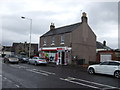
9
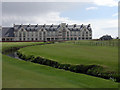
Carnoustie Golf Hotel
The hotel was built for the 1999 Open Golf Championship. The burn in the foreground is the one where the French golfer Jean van de Velde famously went for a paddle!
Image: © Val Vannet
Taken: 30 May 2005
0.18 miles
10

Carnoustie rooftops
The view is taken from the crescent in the east of the grid square looking south towards the golf links and the wooded areas of MOD land at Buddon Ness
Image: © Val Vannet
Taken: 30 May 2005
0.18 miles