IMAGES TAKEN NEAR TO
Burnside Street, CARNOUSTIE, DD7 7HL
Introduction
This page details the photographs taken nearby to Burnside Street, DD7 7HL by members of the Geograph project.
The Geograph project started in 2005 with the aim of publishing, organising and preserving representative images for every square kilometre of Great Britain, Ireland and the Isle of Man.

There are currently over 7.5m images from over14,400 individuals and you can help contribute to the project by visiting https://www.geograph.org.uk
Image Map
Images are licensed for reuse under creativecommons.org/licenses/by-sa/2.0
Notes
- Clicking on the map will re-center to the selected point.
- The higher the marker number, the further away the image location is from the centre of the postcode.
Image Listing (41 Images Found)
Images are licensed for reuse under creativecommons.org/licenses/by-sa/2.0
Image
Details
Distance
1
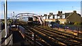
Golf Street Station
Train passing through without stopping
Image: © Jim Smillie
Taken: 21 Nov 2015
0.10 miles
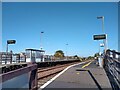
2

Golf Street Station
One of the least used stations in the UK. Generally less than 1000 passengers a year.
Image: © Peter Moore
Taken: 28 Jul 2022
0.11 miles
3
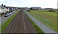
The Edinburgh to Aberdeen railway line at Carnoustie
On the right is the Carnoustie Golf Links, one of the venues in the Open Championship rotation. Between 1931 and 2018, the course has hosted the championship eight times.
Image: © Mat Fascione
Taken: 26 Jun 2017
0.12 miles
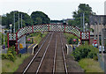
4
Golf Street Railway Station
Golf Street Station opened in 1960 as Golf Street Halt before changing to its current name in 1983.
Image: © Ross Murison
Taken: 25 May 2021
0.12 miles
5

Golf Street railway station, Angus
Opened in 1960 by British Rail on the line from Dundee to Arbroath.
View east towards Carnoustie and Arbroath.
Image: © Nigel Thompson
Taken: 28 May 2014
0.12 miles
6
Golf Street railway station at Carnoustie
On the Edinburgh to Aberdeen railway line.
Image: © Mat Fascione
Taken: 26 Jun 2017
0.12 miles
7
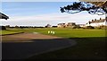
1st Tee Burnside Course
On a bright Saturday morning
Image: © Jim Smillie
Taken: 21 Nov 2015
0.12 miles
8
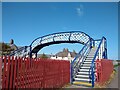
Taymouth Street Footbridge
Just over 200m away from Golf Street Station is this footbridge, which takes one from Taymouth Street or Brown Street over to the path along Carnoustie Golf Links.
Image: © Ross Murison
Taken: 25 May 2021
0.13 miles
9

Carnoustie rooftops
The view is taken from the crescent in the east of the grid square looking south towards the golf links and the wooded areas of MOD land at Buddon Ness
Image: © Val Vannet
Taken: 30 May 2005
0.13 miles
10
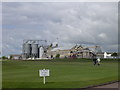
Carnoustie golf course with industrial 'backdrop'
Landward of the golf course is the main east coast railway line and the Carnoustie maltings (closed in 2004) with its distinctive silos and the Panmure Works which is a former textile factory. It now operates as the HQ for a local supermarket company.
Image: © Val Vannet
Taken: 30 May 2005
0.13 miles