IMAGES TAKEN NEAR TO
Kinbrae Court, NEWPORT-ON-TAY, DD6 8HF
Introduction
This page details the photographs taken nearby to Kinbrae Court, DD6 8HF by members of the Geograph project.
The Geograph project started in 2005 with the aim of publishing, organising and preserving representative images for every square kilometre of Great Britain, Ireland and the Isle of Man.

There are currently over 7.5m images from over14,400 individuals and you can help contribute to the project by visiting https://www.geograph.org.uk
Image Map
Images are licensed for reuse under creativecommons.org/licenses/by-sa/2.0
Notes
- Clicking on the map will re-center to the selected point.
- The higher the marker number, the further away the image location is from the centre of the postcode.
Image Listing (53 Images Found)
Images are licensed for reuse under creativecommons.org/licenses/by-sa/2.0
Image
Details
Distance
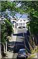
1

Towerblock, Newport-on-Tay
A small tower block in Kinbrae Park, Newport-on-Tay.
Image: © Colin Kinnear
Taken: 12 Nov 2010
0.04 miles
2
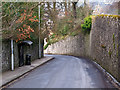
Boat Brae, Newport on Tay
Boat Brae - the B946 - at Newport on Tay.
Image: © William Starkey
Taken: 4 Mar 2013
0.06 miles
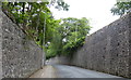
4
Boat Brae, Newport
From the High Road with the pier buildings in the distance.
Image: © Jim Bain
Taken: 15 May 2007
0.07 miles
5
Pier buildings, Newport
From the foot of Boat Brae.
Image: © Jim Bain
Taken: 15 May 2007
0.09 miles
6
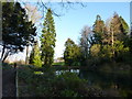
Ornamental pond
On the Tayfield Estate, south of Newport-on-Tay.
Image: © James Allan
Taken: 26 Jan 2015
0.12 miles

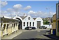
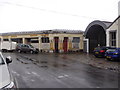
8

Detail of ferry terminal buildings, Newport on Tay
Fading colours on the ferry terminal building at Newport on Tay. This building was closed in 1966 when the Tay road bridge opened.
Image: © William Starkey
Taken: 4 Mar 2013
0.13 miles
9
Where Boat Road meets Boat Brae, Newport-on-Tay
A neglected ornate structure on Boat Brae (L) abuts the former Ferry Terminal (R) on Boat Road.
Image: © Stanley Howe
Taken: 5 May 2015
0.14 miles
10

Newport pier
A Thomas Telford pier built in 1823. It served as one of the main routes from NE Fife into Dundee and points north for the next 143 years until the 18 Aug 1966 when the Tay road bridge opened for traffic. Now it's used for the servicing and repair of small craft. Tay road bridge and Dundee in the distance.
Image: © Jim Bain
Taken: 15 May 2007
0.14 miles