IMAGES TAKEN NEAR TO
Ferry Road, DUNDEE, DD5 4NZ
Introduction
This page details the photographs taken nearby to Ferry Road, DD5 4NZ by members of the Geograph project.
The Geograph project started in 2005 with the aim of publishing, organising and preserving representative images for every square kilometre of Great Britain, Ireland and the Isle of Man.

There are currently over 7.5m images from over14,400 individuals and you can help contribute to the project by visiting https://www.geograph.org.uk
Image Map
Images are licensed for reuse under creativecommons.org/licenses/by-sa/2.0
Notes
- Clicking on the map will re-center to the selected point.
- The higher the marker number, the further away the image location is from the centre of the postcode.
Image Listing (20 Images Found)
Images are licensed for reuse under creativecommons.org/licenses/by-sa/2.0
Image
Details
Distance
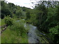
1

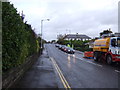
The Dighty Burn , Monifieth
The view downstream from the road bridge with a very recent housing development on the site of former industrial premises.
Image: © AlastairG
Taken: 8 Jul 2014
0.05 miles
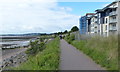
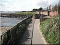
2
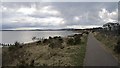
Angus coastal path
Leaving Monifieth for Broughty Ferry.
Image: © Richard Webb
Taken: 23 Feb 2013
0.09 miles
3
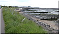
Groynes along the shore at Monifieth Sands
Image: © Mat Fascione
Taken: 26 Jun 2017
0.10 miles
7
Angus Coastal Path at Monifieth
Part of National Cycle Route 1. Broughty Ferry is visible in the distance.
Image: © Mat Fascione
Taken: 26 Jun 2017
0.12 miles
8
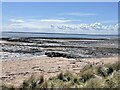
Looking along Monifieth Sands towards Broughty Ferry
A nice wildlife beach, full of the sounds of seabirds. In the distance, over the River Tay estuary, stretches the Tentsmuir Nature Reserve, nesting place to white-tailed eagles.
Image: © Andrew Shannon
Taken: 11 May 2023
0.13 miles
10
Dighty Water
Outflow of the Dighty Water into the outer Tay estuary. The river is crossed by the Aberdeen - Dundee railway and a footbridge carrying route 1 of the National Cycle Network.
Image: © Richard Webb
Taken: 7 Sep 2009
0.17 miles