IMAGES TAKEN NEAR TO
Cairnwell Loan, DUNDEE, DD5 3XJ
Introduction
This page details the photographs taken nearby to Cairnwell Loan, DD5 3XJ by members of the Geograph project.
The Geograph project started in 2005 with the aim of publishing, organising and preserving representative images for every square kilometre of Great Britain, Ireland and the Isle of Man.

There are currently over 7.5m images from over14,400 individuals and you can help contribute to the project by visiting https://www.geograph.org.uk
Image Map
Images are licensed for reuse under creativecommons.org/licenses/by-sa/2.0
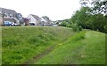
Notes
- Clicking on the map will re-center to the selected point.
- The higher the marker number, the further away the image location is from the centre of the postcode.
Image Listing (24 Images Found)
Images are licensed for reuse under creativecommons.org/licenses/by-sa/2.0
Image
Details
Distance
1
Remnant of an old mill lade above the Dighty Water
The Dighty Water was a hard worked stream in the days of water power.
New housing has replaced the bleachfield that was around here.
Image: © Russel Wills
Taken: 17 Jun 2018
0.05 miles
2
A 'mast' see!!!!
As we were walking along the Dighty Burn, my niece asked me to spot the mobile phone mast ~ can you? It is certainly more aesthetically pleasing than most of the masts in the local area.
Image: © Gwen and James Anderson
Taken: 26 Jun 2007
0.07 miles
3
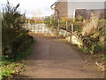
Bridge over burn near the Seven Arches
This ancient stone bridge sits at the edge of a modern housing estate.
Image: © Douglas Nelson
Taken: 27 Nov 2012
0.08 miles
4
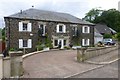
Eriboll on Panmurefield Road
With grounds running down to Dighty Water.
Image: © Russel Wills
Taken: 17 Jun 2018
0.08 miles
5
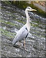
Heron on a weir
On Dighty Water near Balmossie Mill.
Image: © Russel Wills
Taken: 17 Jun 2018
0.08 miles
6
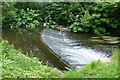
Weir on the Dighty Water
The Dighty powered many mills on its way from the Sidlaw hills to Monifieth sands.
Note the heron waiting for lunch!
Image: © Russel Wills
Taken: 17 Jun 2018
0.09 miles
7

The mighty Dighty, weir than its name suggests?
The Dighty Water separates Broughty Ferry from Monifieth. This weir is haunt of the grey heron. There is an old fish ladder on the far bank.
Image: © John McMillan
Taken: 30 Apr 2006
0.10 miles
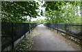
8
Monifieth path network
New houses beside one of the paths in an extensive network of foot and cycle paths in the area.
Image: © AlastairG
Taken: 8 Jul 2014
0.13 miles
9
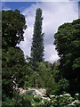
Seven Arches viaduct
A hot afternoon after a very wet morning had mist rising off the damp path and vegetation.
Image: © AlastairG
Taken: 8 Jul 2014
0.15 miles
10
Balmossie Seven Arch Viaduct
The Forfar District Railway (Dundee to Forfar) was opened by the Caledonian Railway Co in 1870. WilliamLeslie was the contractor for the bridge's construction. Balmossie viaduct is no longer used for its original purpose but remains an important picturesque element in the landscape. The railings were added by the District Council to allow the safe passage of pedestrians.
For view from below see https://www.geograph.org.uk/photo/5813690
Image: © Russel Wills
Taken: 18 Jun 2018
0.16 miles