IMAGES TAKEN NEAR TO
Kingennie, Broughty Ferry, DUNDEE, DD5 3RD
Introduction
This page details the photographs taken nearby to DD5 3RD by members of the Geograph project.
The Geograph project started in 2005 with the aim of publishing, organising and preserving representative images for every square kilometre of Great Britain, Ireland and the Isle of Man.

There are currently over 7.5m images from over14,400 individuals and you can help contribute to the project by visiting https://www.geograph.org.uk
Image Map
Images are licensed for reuse under creativecommons.org/licenses/by-sa/2.0
Notes
- Clicking on the map will re-center to the selected point.
- The higher the marker number, the further away the image location is from the centre of the postcode.
Image Listing (10 Images Found)
Images are licensed for reuse under creativecommons.org/licenses/by-sa/2.0
Image
Details
Distance
1
Approaching Kingennie House from the south
Image: © Elliott Simpson
Taken: 5 Aug 2015
0.04 miles
2
Cottage near Kingennie
White cottage to the west of the road at Kingennie.
Image: © Scott Cormie
Taken: 12 Jun 2020
0.13 miles
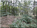
3
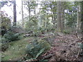
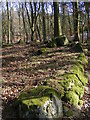
St Bride's Ring, Kingennie
St Bride's Ring is now largely overgrown in a wooded hill near Kingennie. It measured roughly 60 feet in diameter. Many of the large rocks which formed the 7 foot high wall lie below.
St Bride's ring has been classified as a broch by some authorities. It is similar to some of the ring forts of central Perthshire.
See also http://www.monifiethhistorysociety.co.uk/2013/10/22/st-brides-ring/
Image: © Douglas Nelson
Taken: 4 Oct 2015
0.16 miles
5
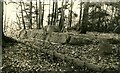
St Bride's Ring
An Iron Age fortification (Scale 2m) https://monifiethhistorysociety.co.uk/2013/10/22/st-brides-ring/
Image: © Sandy Gerrard
Taken: Unknown
0.16 miles
7
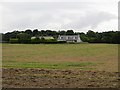
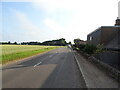
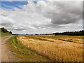
Kingennie
Another example of a lack of fence or hedge beside the road in arable country.
Image: © Richard Webb
Taken: 15 Aug 2013
0.20 miles
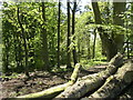
8
St Brides Ring
St Bride's ring is a hillfort, classified as a broch by some authorities, although it lacks the structural details of this type of monument. It is comparable with the ring forts of central Perthshire.
Image: © Karen Vernon
Taken: 6 Mar 2006
0.20 miles
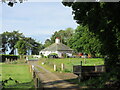
9
Track and field at Omachie, Kingennie
Image: © Douglas Nelson
Taken: 6 Aug 2015
0.23 miles