IMAGES TAKEN NEAR TO
Kingennie, Broughty Ferry, DUNDEE, DD5 3PA
Introduction
This page details the photographs taken nearby to DD5 3PA by members of the Geograph project.
The Geograph project started in 2005 with the aim of publishing, organising and preserving representative images for every square kilometre of Great Britain, Ireland and the Isle of Man.

There are currently over 7.5m images from over14,400 individuals and you can help contribute to the project by visiting https://www.geograph.org.uk
Image Map
Images are licensed for reuse under creativecommons.org/licenses/by-sa/2.0
Notes
- Clicking on the map will re-center to the selected point.
- The higher the marker number, the further away the image location is from the centre of the postcode.
Image Listing (18 Images Found)
Images are licensed for reuse under creativecommons.org/licenses/by-sa/2.0
Image
Details
Distance
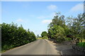
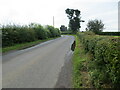
4
Road at South Kingennie
Looking westward.
Image: © Peter Wood
Taken: 11 Aug 2021
0.07 miles
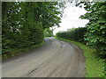
5
Road near to South Kingennie
Looking south-eastward.
Image: © Peter Wood
Taken: 11 Aug 2021
0.15 miles
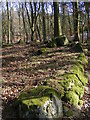
6
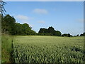
Cereal crop, South Kingennie
The line of trees marks the course of the former Dundee to Forfar railway.
Image: © JThomas
Taken: 20 Jul 2021
0.17 miles
7
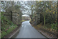
Dismantled railway bridge near Murroes
Image: © Steven Brown
Taken: 20 Nov 2012
0.17 miles
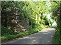
8
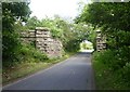
Abutments for a dismantled railway bridge
On the former Forfar District Railway (Dundee to Forfar) that was opened by the Caledonian Railway Co in 1870.
Image: © Russel Wills
Taken: 18 Jun 2018
0.18 miles
9
Remnant of railway bridge
Remains of the bridge that carried the Dundee to Forfar railway line over the C4 (Angus) road to the east of Murroes.
Image: © Scott Cormie
Taken: 12 Jun 2020
0.18 miles
10
St Brides Ring
St Bride's ring is a hillfort, classified as a broch by some authorities, although it lacks the structural details of this type of monument. It is comparable with the ring forts of central Perthshire.
Image: © Karen Vernon
Taken: 6 Mar 2006
0.18 miles