IMAGES TAKEN NEAR TO
Inchcape Place, DUNDEE, DD5 2LP
Introduction
This page details the photographs taken nearby to Inchcape Place, DD5 2LP by members of the Geograph project.
The Geograph project started in 2005 with the aim of publishing, organising and preserving representative images for every square kilometre of Great Britain, Ireland and the Isle of Man.

There are currently over 7.5m images from over14,400 individuals and you can help contribute to the project by visiting https://www.geograph.org.uk
Image Map
Images are licensed for reuse under creativecommons.org/licenses/by-sa/2.0
Notes
- Clicking on the map will re-center to the selected point.
- The higher the marker number, the further away the image location is from the centre of the postcode.
Image Listing (16 Images Found)
Images are licensed for reuse under creativecommons.org/licenses/by-sa/2.0
Image
Details
Distance
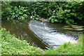
1

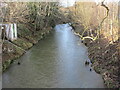
The mighty Dighty, weir than its name suggests?
The Dighty Water separates Broughty Ferry from Monifieth. This weir is haunt of the grey heron. There is an old fish ladder on the far bank.
Image: © John McMillan
Taken: 30 Apr 2006
0.09 miles
2
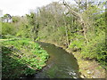
The Dighty Burn at Balmossie
The Dighty rises in the Sidlaws and runs for 15 miles before reaching the Tay estuary at Monifieth.
Image: © Euan Nelson
Taken: 9 May 2015
0.10 miles
3
Weir on the Dighty Water
The Dighty powered many mills on its way from the Sidlaw hills to Monifieth sands.
Note the heron waiting for lunch!
Image: © Russel Wills
Taken: 17 Jun 2018
0.11 miles
4
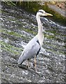
Heron on a weir
On Dighty Water near Balmossie Mill.
Image: © Russel Wills
Taken: 17 Jun 2018
0.11 miles
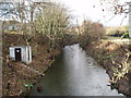
6
Dighty Water
The Dighty Water looking upstream from the footbridge off Balgillo Road.
Image: © Scott Cormie
Taken: 2 Jan 2022
0.14 miles
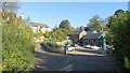
8

Eriboll on Panmurefield Road
With grounds running down to Dighty Water.
Image: © Russel Wills
Taken: 17 Jun 2018
0.16 miles
9
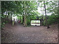
Footpath and cycle path on line of former railway
The bridge is all that remains of the railway infrastructure at this point
Image: © Douglas Nelson
Taken: 1 Jul 2015
0.18 miles
10
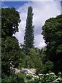
A 'mast' see!!!!
As we were walking along the Dighty Burn, my niece asked me to spot the mobile phone mast ~ can you? It is certainly more aesthetically pleasing than most of the masts in the local area.
Image: © Gwen and James Anderson
Taken: 26 Jun 2007
0.18 miles