IMAGES TAKEN NEAR TO
Albany Park, DUNDEE, DD5 1PD
Introduction
This page details the photographs taken nearby to Albany Park, DD5 1PD by members of the Geograph project.
The Geograph project started in 2005 with the aim of publishing, organising and preserving representative images for every square kilometre of Great Britain, Ireland and the Isle of Man.

There are currently over 7.5m images from over14,400 individuals and you can help contribute to the project by visiting https://www.geograph.org.uk
Image Map
Images are licensed for reuse under creativecommons.org/licenses/by-sa/2.0
Notes
- Clicking on the map will re-center to the selected point.
- The higher the marker number, the further away the image location is from the centre of the postcode.
Image Listing (10 Images Found)
Images are licensed for reuse under creativecommons.org/licenses/by-sa/2.0
Image
Details
Distance
1
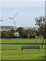
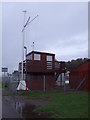
Dawson Park
Park, West Ferry with one of a pair of long established wind turbines in the background.
Image: © Richard Webb
Taken: 27 Sep 2014
0.20 miles
2

Main line to Dundee
The railway from Aberdeen to Dundee, seen from a footbridge in West Ferry.
Image: © James Allan
Taken: 21 Feb 2011
0.23 miles
4
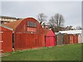
Boat houses, Broughty Ferry
A strip between firth and railway is home to several sailing clubs.
Image: © Richard Webb
Taken: 23 Feb 2013
0.24 miles
5
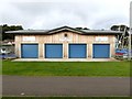
The Brot'y Boathouse
Boathouse accommodating Tay Sail Training and Broughty Ferry Boating. Built in 2014 to replace an older boathouse - see Image The coastal path runs to the front.
Image: © Oliver Dixon
Taken: 16 Sep 2018
0.24 miles
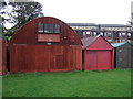
7
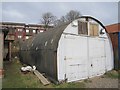
Boat house
A Nissen hut put to use by a sailing club.
Image: © Richard Webb
Taken: 23 Feb 2013
0.25 miles
8

Beach club house (RTYC), Broughty Ferry
The beach club house of the Royal Tay Yacht Club. There is a more substantial and modern looking clubhouse some distance east and landinward.
Image: © Dan
Taken: 10 Mar 2009
0.25 miles
9
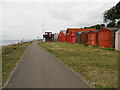
Boat sheds at Grassy Beach
The path here is part of the National Cycle Network
Image: © Douglas Nelson
Taken: 4 Sep 2013
0.25 miles
10
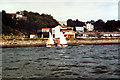
Teaching Sailing at Grassy Beach
View from the safety boat of the Wayfarer dinghies used for teaching sailing to Royal Yachting Association standards at Tayside Regional Council's Outdoor Education base at Grassy Beach. This photo would have been taken in the mid 1980's. Sailing took place two days a week and at weekends.
Image: © Ian Paterson
Taken: Unknown
0.25 miles