IMAGES TAKEN NEAR TO
Isla Street, DUNDEE, DD3 7HT
Introduction
This page details the photographs taken nearby to Isla Street, DD3 7HT by members of the Geograph project.
The Geograph project started in 2005 with the aim of publishing, organising and preserving representative images for every square kilometre of Great Britain, Ireland and the Isle of Man.

There are currently over 7.5m images from over14,400 individuals and you can help contribute to the project by visiting https://www.geograph.org.uk
Image Map
Images are licensed for reuse under creativecommons.org/licenses/by-sa/2.0
Notes
- Clicking on the map will re-center to the selected point.
- The higher the marker number, the further away the image location is from the centre of the postcode.
Image Listing (56 Images Found)
Images are licensed for reuse under creativecommons.org/licenses/by-sa/2.0
Image
Details
Distance
1
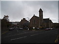
Coldside Parish Church, Dundee
Formerly Clepington Church, Coldside Parish Church was formed as a result of a union between Fairmuir and Clepington Churches.
Image: © Douglas Nelson
Taken: 28 Apr 2016
0.05 miles
2
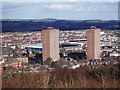
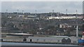
Colour co-ordinated multis
The colour feature almost matches the colours of the two senior teams in Dundee. The football ground on left is Dens Park where Dundee F.C. play in dark blue. The one on the right is Tannadice Park home of Dundee United who play in tangerine.
Image: © Douglas Nelson
Taken: 5 Mar 2012
0.07 miles
3
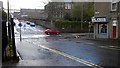
Isla Street / Dens Road Junction
On a wet Dundee day
Image: © Jim Bain
Taken: 23 Apr 2012
0.07 miles
4
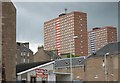
The Multis
Like most industrial cities in Britain, Dundee has its fair share of high rise flats or ''The Multis'' as they are known locally. The block on the left is Bucklemakers Court and other one is Butterburn Court.
Image: © Paul McIlroy
Taken: 6 Jul 2007
0.13 miles
5
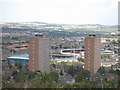
Football grounds
View from The Law of the two closest footballing neighbours. Dens Park nearest (Dundee) and Dundee United's Tannadice just over the road.
Image: © Richard Webb
Taken: 21 Aug 2009
0.13 miles
6
Floodlight forest
9 floodlight pylons (Dundee United seem to have 5) seen from near Tayport in Fife. The two closest football grounds in Britain, either side of Tannadice Road. Dundee on the left, Dundee United on the right.
I remember they were separated by a street and a small bit of ground with a "no ball games" notice.
Image: © Richard Webb
Taken: 21 Aug 2009
0.13 miles
7

Flats and football grounds
The highest point in Dundee is at the top of the volcanic plug know as Dundee Law. This is where the memorial to the local men and women who lost their lives in the 1914-18 war, is situated. It is a good point to view Dundee and the Tay estuary.This picture shows the multi- storey flats at Strathmartine Road and the football grounds of Dundee FC (Dens Park) and Dundee United (Tannadice Park)
Image: © Paul McIlroy
Taken: 8 Nov 2008
0.13 miles
8

Dens Park, Dundee
Dens Park, home of Dundee football club. The photograph is taken from the away end with the visitors being Queen of the South Football Club.
Image: © Colin Kinnear
Taken: 15 Nov 2008
0.13 miles
9
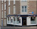
The Snug
Well known Dundee pub frequented by football fans.
Image: © Paul McIlroy
Taken: 6 Jul 2007
0.14 miles
10
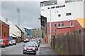
Tannadice Street
The nearest neighbours in British senior football are to be found here on Tannadice Street in Dundee. Tannadice Park, home to Dundee United is on the right of the picture, and Dens Park where Dundee FC play their home games can be seen at the top of the street.
Image: © Paul McIlroy
Taken: 6 Jul 2007
0.14 miles