IMAGES TAKEN NEAR TO
Upper Constitution Street, DUNDEE, DD3 6JW
Introduction
This page details the photographs taken nearby to Upper Constitution Street, DD3 6JW by members of the Geograph project.
The Geograph project started in 2005 with the aim of publishing, organising and preserving representative images for every square kilometre of Great Britain, Ireland and the Isle of Man.

There are currently over 7.5m images from over14,400 individuals and you can help contribute to the project by visiting https://www.geograph.org.uk
Image Map
Images are licensed for reuse under creativecommons.org/licenses/by-sa/2.0
Notes
- Clicking on the map will re-center to the selected point.
- The higher the marker number, the further away the image location is from the centre of the postcode.
Image Listing (70 Images Found)
Images are licensed for reuse under creativecommons.org/licenses/by-sa/2.0
Image
Details
Distance
1
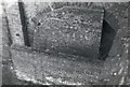
South end of the Dundee Newtyle Railway's tunnel under the Law
Built in the 1829, taken out of use in the 1860s, used as an air-raid shelter during World War II and covered over in 1982
Image: © Elliott Simpson
Taken: Unknown
0.02 miles
2
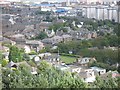
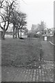
Bowling green
Bowling green off Fingask Road and rooftops seen from Dundee Law.
Image: © Richard Webb
Taken: 21 Aug 2009
0.03 miles
3
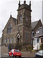
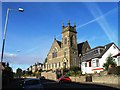
High Kirk, Dundee
Not "high" ecclesiastically but "high" in altitude being close to the highest point in Dundee, Dundee Law
Image: © Douglas Nelson
Taken: 25 Apr 2013
0.07 miles
4
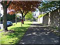
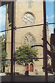
Drummond Street, Dundee
The track of the 1830s Dundee to Newtyle Railway ran up an incline between the line of trees and the road on the right towards the tunnel - the entrance of the tunnel was under the church seen in the distance.
Image: © Elliott Simpson
Taken: 12 May 2009
0.07 miles
6
Architectural Comparison Dundee
From Commerce to Church, Dundee central
Image: © MDS
Taken: 4 Sep 2006
0.08 miles
7
Drummond Street, Dundee
The track of the 1830s Dundee to Newtyle Railway ran up an incline between the line of trees and the road on the right towards the tunnel - the entrance of the tunnel was under the church seen in the distance.
Image: © Elliott Simpson
Taken: Unknown
0.08 miles
8
Water tower on lower slopes of Dundee Law
Image: © Douglas Nelson
Taken: 28 Apr 2016
0.10 miles
9
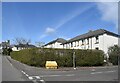
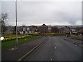
Former council houses, Upper Constitution Street, Dundee
St David's High Kirk just peeps into the picture on the left.
Image: © Bill Harrison
Taken: 9 Apr 2022
0.11 miles
10
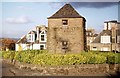
Old Water Tower on the easy slope of the Dundee Law
Image: © Elliott Simpson
Taken: Unknown
0.11 miles