IMAGES TAKEN NEAR TO
ARBROATH, DD11 4RS
Introduction
This page details the photographs taken nearby to DD11 4RS by members of the Geograph project.
The Geograph project started in 2005 with the aim of publishing, organising and preserving representative images for every square kilometre of Great Britain, Ireland and the Isle of Man.

There are currently over 7.5m images from over14,400 individuals and you can help contribute to the project by visiting https://www.geograph.org.uk
Image Map
Images are licensed for reuse under creativecommons.org/licenses/by-sa/2.0
Notes
- Clicking on the map will re-center to the selected point.
- The higher the marker number, the further away the image location is from the centre of the postcode.
Image Listing (5 Images Found)
Images are licensed for reuse under creativecommons.org/licenses/by-sa/2.0
Image
Details
Distance
1
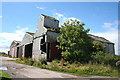
Barns at Border
The maps are not unaninmous about the name of this farm. Some name it as Border but others say East Border.
Image: © Anne Burgess
Taken: 7 Aug 2017
0.06 miles
2
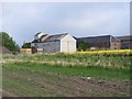
Border Farm
This farm sits down a little track in the middle of nowhere.
Image: © Dominic Dawn Harry and Jacob Paterson
Taken: 7 Jun 2006
0.06 miles
3
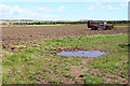
Field near Border Farm
Flat farmlands near Friockheim.
Image: © Anne Burgess
Taken: 7 Aug 2017
0.13 miles
4
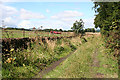
Grassy Track
This track links Border to West Border, but doesn't seem to be much used now.
Image: © Anne Burgess
Taken: 7 Aug 2017
0.17 miles
5
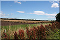
Fields at East Border
A russet fringe of withered sourocks (docks) frames a view over flat land near Friockheim.
Image: © Anne Burgess
Taken: 7 Aug 2017
0.22 miles