IMAGES TAKEN NEAR TO
MONTROSE, DD10 9TT
Introduction
This page details the photographs taken nearby to DD10 9TT by members of the Geograph project.
The Geograph project started in 2005 with the aim of publishing, organising and preserving representative images for every square kilometre of Great Britain, Ireland and the Isle of Man.

There are currently over 7.5m images from over14,400 individuals and you can help contribute to the project by visiting https://www.geograph.org.uk
Image Map
Images are licensed for reuse under creativecommons.org/licenses/by-sa/2.0
Notes
- Clicking on the map will re-center to the selected point.
- The higher the marker number, the further away the image location is from the centre of the postcode.
Image Listing (42 Images Found)
Images are licensed for reuse under creativecommons.org/licenses/by-sa/2.0
Image
Details
Distance
1
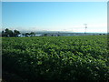
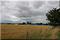
Potato field viewed from Kirkton of Craig by Montrose
This photo shows a field of potatoes as viewed from near Kirkton House, the former Manse of Craig.
Image: © Adrian Diack
Taken: 23 Jul 2016
0.01 miles
2
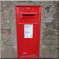
Victorian Wallbox at Kirkton of Craig
VR embossed wallbox on the south side of the road at the Kirkton of Craig.
Image: © Scott Cormie
Taken: 28 Dec 2017
0.03 miles
3
Old church tower at Kirkton of Craig
From Craig Road looking across to the old church tower at Kirkton of Craig
Image: © Shaun Ferguson
Taken: 17 Aug 2011
0.03 miles
4
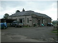
Former Craig Primary School, Kirkton of Craig, by Montrose
This photo shows the former Craig Primary School and one of the two playgrounds. The former school is now a dwelling house.
Image: © Adrian Diack
Taken: 20 Aug 2020
0.04 miles
5

Former Craig Primary School converted to a house
This photo shows the former Craig Primary School, Kirkton of Craig, which has been converted to the house named Craigwell.
Image: © Adrian Diack
Taken: 22 Aug 2020
0.04 miles
6
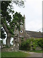
Kirk Tower House
The old church at Kirkton of Craig is now a private home.
Image: © James Denham
Taken: 1 Jun 2010
0.04 miles
7
Kirkton of Craig viewed from a west-northwestery direction
This photo shows Kirkton of Craig, by Montrose, viewed from a west-northwesterly direction.
Image: © Adrian Diack
Taken: 22 Aug 2020
0.04 miles
8
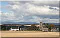
Kirkton of Craig viewed from Craig Road
This photo shows Kirkton of Craig viewed from Craig Road. The most westerly white house is the old schoolhouse, the centrally positioned church was built in 1799 and the old manse is the white to pink coloured building on the eastern end of the village.
Image: © Adrian Diack
Taken: 22 Aug 2020
0.04 miles
9
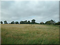
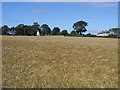
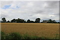
Barley field between Barns of Craig and Kirkton of Craig, Montrose
This westward view shows a field of growing barley between Barns of Craig and Kirkton of Craig by Montrose. The village in the photo is Kirkton of Craig.
Image: © Adrian Diack
Taken: 20 Aug 2020
0.05 miles
10
Kirkton of Craig
The former Craig Parish Kirk, complete with square tower, is now a private house.
Image: © Anne Burgess
Taken: 5 Oct 2012
0.05 miles