IMAGES TAKEN NEAR TO
Beachgate, MONTROSE, DD10 0QZ
Introduction
This page details the photographs taken nearby to Beachgate, DD10 0QZ by members of the Geograph project.
The Geograph project started in 2005 with the aim of publishing, organising and preserving representative images for every square kilometre of Great Britain, Ireland and the Isle of Man.

There are currently over 7.5m images from over14,400 individuals and you can help contribute to the project by visiting https://www.geograph.org.uk
Image Map
Images are licensed for reuse under creativecommons.org/licenses/by-sa/2.0
Notes
- Clicking on the map will re-center to the selected point.
- The higher the marker number, the further away the image location is from the centre of the postcode.
Image Listing (106 Images Found)
Images are licensed for reuse under creativecommons.org/licenses/by-sa/2.0
Image
Details
Distance
1
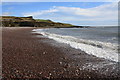
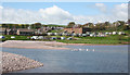
Campsite, Inverbervie
Great wee campsite overlooking Bervie Bay and to the North Sea. Taken from the other side of the Bervie Water.
Image: © Dona Robbins
Taken: 30 Oct 2010
0.01 miles
2
Bervie Water
The Bervie Water forms a lagoon here before it flows over a natural rock dam into the sea. On the south bank is a caravan and camping site, with the town itself standing on a raised beach several metres above the present beach, a relic of a time when the relative sea level was higher than it is today.
Image: © Anne Burgess
Taken: 1 Jun 2013
0.03 miles
3
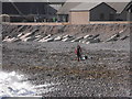
Fishing at Bay of Bervie, Inverbervie
On a most beautiful day at the end of October who wouldn't want to go fishing?
Image: © Dona Robbins
Taken: 30 Oct 2010
0.04 miles
4

Beach Inverbervie
Beautiful beach at Inverbervie with waves crashing on the pebbles and shingle.
Image: © Mary Rodgers
Taken: 12 Apr 2018
0.04 miles
5
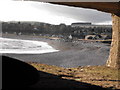
Inverbervie Bay from Pillbox
Taken from the central aperture of the pillbox looking over Bervie Bay and south end of Inverbervie. The figure in the centre is a fisherman setting up. Blob on the left is a pebble thrown up by the waves. The floor of the pillbox is covered in pebbles - and inevitably broken glass and beer cans.
Image: © Dona Robbins
Taken: 30 Oct 2010
0.05 miles
6
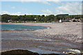
Bervie Bay
The bay is backed by a curve of pebbles piled up by the sea. In the foreground, the Bervie Water finally reaches the sea. Modern houses have been built on the low ground by the shore.
Image: © Anne Burgess
Taken: 1 Jun 2013
0.05 miles
7
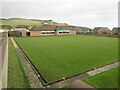
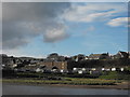
Bervie Bowling Club
The bowling green from Kirkburn in Inverbervie.
Image: © Scott Cormie
Taken: 25 Nov 2022
0.05 miles
8
Site of Inverbervie station, 2002
View SE, towards Montrose; ex-NBR Montrose - Inverbervie branch, which closed for passengers on 4/5/64, for goods on 25/1/65. The station had been on the right, called 'Bervie' until 5/7/26. There is not much change since 1974: Image
Image: © Ben Brooksbank
Taken: 29 Jun 2002
0.06 miles
9

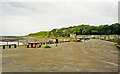
Bervie Bay
Looking north from the beach carpark across the mouth of Bervie Water.
Image: © Oliver Dixon
Taken: 5 Jun 2021
0.06 miles