IMAGES TAKEN NEAR TO
Linton Road, MONTROSE, DD10 0NH
Introduction
This page details the photographs taken nearby to Linton Road, DD10 0NH by members of the Geograph project.
The Geograph project started in 2005 with the aim of publishing, organising and preserving representative images for every square kilometre of Great Britain, Ireland and the Isle of Man.

There are currently over 7.5m images from over14,400 individuals and you can help contribute to the project by visiting https://www.geograph.org.uk
Image Map
Images are licensed for reuse under creativecommons.org/licenses/by-sa/2.0
Notes
- Clicking on the map will re-center to the selected point.
- The higher the marker number, the further away the image location is from the centre of the postcode.
Image Listing (17 Images Found)
Images are licensed for reuse under creativecommons.org/licenses/by-sa/2.0
Image
Details
Distance
1
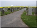
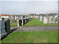
Bervie Cemetery
Bervie Cemetery just North of Gourdon
Image: © Shaun Ferguson
Taken: 4 Jun 2010
0.11 miles
2
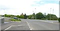
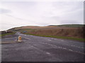
Bend in minor road out of Gourdon
With offtakes for two lanes on the right. Seen from a lay-by serving new (unmapped as yet) houses on the left.
Image: © Stanley Howe
Taken: 12 Jul 2017
0.14 miles
4
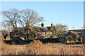
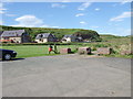
Sillyflatt Farm
An arable farm by the A92 south of Inverbervie. It has in the past hosted music gigs in the barn.
Image: © Andrew Wood
Taken: 19 Nov 2016
0.17 miles
5
Bottle Craig, Gourdon
From end of public road in Gourdon.
Image: © Stanley Howe
Taken: 31 Jul 2007
0.19 miles
6
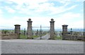
Gates to Gourdon Cemetery
Off Brae Road. North Sea in background.
Image: © Stanley Howe
Taken: 12 Jul 2017
0.20 miles
7
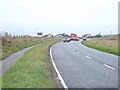
A92 Near Gourdon
You can see Coastal Cuisine in the background, an excellent snack bar
Image: © Dominic Dawn Harry and Jacob Paterson
Taken: 22 Jan 2006
0.20 miles
8
A part of Gourdon Cemetery
Looking westward towards private housing on Brae Road.
Image: © Peter Wood
Taken: 8 Aug 2021
0.21 miles
9

Ordnance Survey Cut Mark
This mark can be found on the roadside boundary wall of Gourdon Cemetery.
The recorded details give a height of 40.4409 metres above sea level.
For more detail see : https://www.bench-marks.org.uk/bm162450
Image: © Peter Wood
Taken: 8 Aug 2021
0.21 miles
10
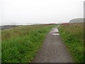
Kincardineshire coast path, Gourdon
Approaching Gourdon on a wet evening. The coast path uses the trackbed of the Montrose and Bervie Railway here, and is reasonably well surfaced. Things get a bit rougher south of Gourdon, but it is a great route.
This is a raised beach.
Image: © Richard Webb
Taken: 2 Aug 2011
0.22 miles