IMAGES TAKEN NEAR TO
St. Cyrus, MONTROSE, DD10 0DW
Introduction
This page details the photographs taken nearby to DD10 0DW by members of the Geograph project.
The Geograph project started in 2005 with the aim of publishing, organising and preserving representative images for every square kilometre of Great Britain, Ireland and the Isle of Man.

There are currently over 7.5m images from over14,400 individuals and you can help contribute to the project by visiting https://www.geograph.org.uk
Image Map
Images are licensed for reuse under creativecommons.org/licenses/by-sa/2.0
Notes
- Clicking on the map will re-center to the selected point.
- The higher the marker number, the further away the image location is from the centre of the postcode.
Image Listing (16 Images Found)
Images are licensed for reuse under creativecommons.org/licenses/by-sa/2.0
Image
Details
Distance
1
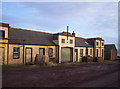
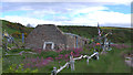
Yellow Steading at East Mathers
Image: © Dominic Dawn Harry and Jacob Paterson
Taken: 21 Jan 2006
0.06 miles
3
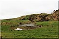
Pool by East Mathers
A pool between the coast and East Mathers.
Image: © Andrew Wood
Taken: 18 Mar 2017
0.10 miles
4
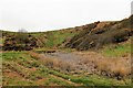
Wetland by East Mathers
A marshy pool by East Mathers.
Image: © Andrew Wood
Taken: 18 Mar 2017
0.14 miles
5
Falling Down
Old building near shore between Miltonhaven and Johnshaven. The building is decorated with lots of bits of driftwood and items washed up on the beach.
Image: © Mary Rodgers
Taken: 30 May 2015
0.17 miles
6
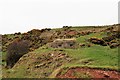
Coast Watch
A wartime pillbox below East Mathers likely placed there to guard the beach below.
Image: © Andrew Wood
Taken: 18 Mar 2017
0.18 miles
7
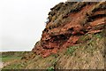
Sandstone Cliff Face
An eroded cliff south of Seagreens by the coastal path.
Image: © Andrew Wood
Taken: 18 Mar 2017
0.20 miles
8
Sandstone and Path
Sandstone boulders and the coastal path south of Seagreens.
Image: © Andrew Wood
Taken: 18 Mar 2017
0.20 miles
9
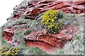
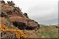
Whin and Sandstone
A contrast between the yellow of the whin and the red of the sandstone by the coastal pathway.
Image: © Andrew Wood
Taken: 18 Mar 2017
0.21 miles
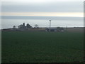
10
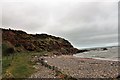
Seagreens Headland
A view north to the headland by Seagreens.
Image: © Andrew Wood
Taken: 18 Mar 2017
0.21 miles