IMAGES TAKEN NEAR TO
Wolsey Crescent, GREENHITHE, DA9 9TG
Introduction
This page details the photographs taken nearby to Wolsey Crescent, DA9 9TG by members of the Geograph project.
The Geograph project started in 2005 with the aim of publishing, organising and preserving representative images for every square kilometre of Great Britain, Ireland and the Isle of Man.

There are currently over 7.5m images from over14,400 individuals and you can help contribute to the project by visiting https://www.geograph.org.uk
Image Map
Images are licensed for reuse under creativecommons.org/licenses/by-sa/2.0
Notes
- Clicking on the map will re-center to the selected point.
- The higher the marker number, the further away the image location is from the centre of the postcode.
Image Listing (25 Images Found)
Images are licensed for reuse under creativecommons.org/licenses/by-sa/2.0
Image
Details
Distance
1
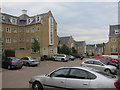
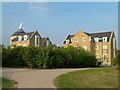
Fusion Apartments at Waterstone Park
The new development Fusion at Waterstone Park has its own play area and access to the common grassed area shared with Sandpiper Close Image Overlooking the Bluewater complex to the south and the Thames to the north most of the residents have a panoramic view.
Image: © Ken Brown
Taken: 28 Jul 2008
0.10 miles
2
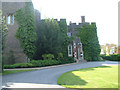
Stone Castle
12th Century Stone Castle. All that remains of the original castle is the tower. It is now used as a banqueting suite for private functions. Taken from the private road to the east.
Image: © Ken Brown
Taken: 9 Jun 2008
0.14 miles
3
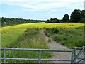
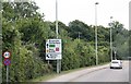
Rapeseed in bloom
View toward Bluewater from London Road, Greenhithe near McDonald's roundabout.
Image: © Ken Brown
Taken: 25 Jun 2008
0.16 miles
5
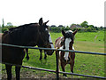
Gypsy Horses
On the unnamed road Image from London Road, Greenhithe towards the new ‘Fusion' development on Waterstone Park a pleasing view is to be had on the right looking towards the rear of the bungalows in Barnfield Close, Horns Cross. Gypsy horses, probably 20 in all. A footpath runs from this point across the field to join up with the close.
Image: © Ken Brown
Taken: 4 May 2008
0.17 miles
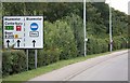
6
Waterstone Park Oast House
As part of the Waterstone Park design to integrate into the landscape a modern 'Fake' Oast has been added. Running Parallel to the London Road, vehicle access is only from Sanderling Way. Ramblers can take the scenic route via the old road Image
Image: © Ken Brown
Taken: 27 Jul 2008
0.18 miles
7
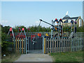
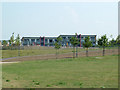
Waterstone Park Playground
Up the hill from Sandpiper Close Image is a purpose built playpark and grassed playing field which overlooks river views to the north and the new Fusion development to the south. It can be only be accessed by foot from either the London road Image or Waterstone Park.
Image: © Ken Brown
Taken: 28 Jul 2008
0.18 miles
8
Waterstone Park, Emergency Access
By foot or in emergencies this is the easiest access to Waterstone Park. Off the A226 London Road by the Waterstone Park bus stop it saves going around the estate and over the multitude of speed bumps.
Image: © Ken Brown
Taken: 28 Jul 2008
0.18 miles