IMAGES TAKEN NEAR TO
Marley Avenue, BEXLEYHEATH, DA7 5RU
Introduction
This page details the photographs taken nearby to Marley Avenue, DA7 5RU by members of the Geograph project.
The Geograph project started in 2005 with the aim of publishing, organising and preserving representative images for every square kilometre of Great Britain, Ireland and the Isle of Man.

There are currently over 7.5m images from over14,400 individuals and you can help contribute to the project by visiting https://www.geograph.org.uk
Image Map
Images are licensed for reuse under creativecommons.org/licenses/by-sa/2.0
Notes
- Clicking on the map will re-center to the selected point.
- The higher the marker number, the further away the image location is from the centre of the postcode.
Image Listing (24 Images Found)
Images are licensed for reuse under creativecommons.org/licenses/by-sa/2.0
Image
Details
Distance
1
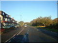
On Bostall Heath
This photograph is taken within a small triangle of Bostall Heath at its southern end and separated by West Heath Road from the main part of Bostall Heath. The road alongside here is Longleigh Lane and the roof tops belong to houses in Brampton Road.
Image: © Marathon
Taken: 9 Apr 2015
0.13 miles
2
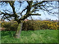
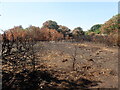
Fire damage on Bostall Heath
This was another baking hot day during the summer of 2022 when it had been the driest period since records began in 1836. Fires on open land were a regular occurrence. This is West Heath which is part of Bostall Heath.
Image: © Marathon
Taken: 12 Aug 2022
0.14 miles
3
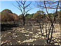
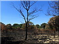
Fire damage on Bostall Heath
This was another baking hot day during the summer of 2022 when it had been the driest period since records began in 1836. Fires on open land were a regular occurrence. This is West Heath which is part of Bostall Heath.
Image: © Marathon
Taken: 12 Aug 2022
0.14 miles
4
Fire damage on Bostall Heath
This was another baking hot day during the summer of 2022 when it had been the driest period since records began in 1836. Fires on open land were a regular occurrence. This is West Heath which is part of Bostall Heath.
Image: © Marathon
Taken: 12 Aug 2022
0.14 miles
5
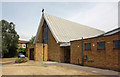
St Andrew, Brampton Road, Bostall Heath, Bexleyheath, Kent DA7
Image: © John Salmon
Taken: 6 Jul 2010
0.15 miles
7
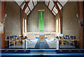
St Andrew, Brampton Road, Bostall Heath, Bexleyheath, Kent DA7 - Sanctuary
Image: © John Salmon
Taken: 6 Jul 2010
0.16 miles
8
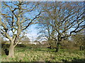
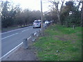
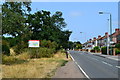
On Bostall Heath
This photograph is taken of the small triangle of Bostall Heath at its southern end and separated by West Heath Road from the main part of Bostall Heath. The road alongside here is Longleigh Lane and the houses in the distance are in Brampton Road.
Image: © Marathon
Taken: 11 Feb 2016
0.16 miles